Rodersdorf geodata
Rodersdorf (Solothurn) is a populated place; located in Switzerland in Europe/Zurich (GMT+2) time zone. With population of 1,338 people, there are 1110 cities with bigger population in this country. Compared to other cities in Switzerland, 86.3% of cities are located further ↓South; 76.7% of cities are located further →East and 92.7% of cities have higher elevation than Rodersdorf. Note1


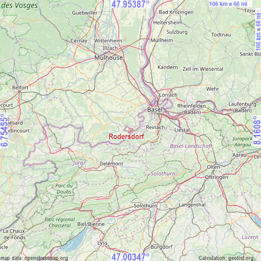
Rodersdorf GPS coordinates[2]
47° 28' 50.952" North, 7° 27' 27.612" East
| Map corner | latitude | longitude |
|---|---|---|
| Upper-left | 47.95387°, | 6.75455° |
| Center: | 47.48082°, | 7.45767° |
| Lower-right: | 47.00347°, | 8.1608° |
| Map W x H: | 105.7×105.7 km | = 65.7×65.7mi |
| max Lat: | 47.76737° ⇑13.7% North |
| Rodersdorf: | 47.48082° |
| min Lat: | ⇓86.3% South 45.83203° |
| min Long | Rodersdorf | max Long |
| 5.97153° | 7.45767° | 10.44624° |
| W 23.3%⇐ | ⇒76.7% E |
Elevation
Elevation of Rodersdorf is 381 m = 1250 ft, and this is 177.2 m = 581 ft below average elevation for this country.
| Max E: |
1845 m = 6053 ft | 92.7% |
| Avg. | 558.2 m = 1831 ft | |
| Rodersdorf | 381 m = 1250 ft | |
Min E: |
197 m = 646 ft | 7.3% |
See also: Switzerland elevation on elevation.city.
Geographical zone
Rodersdorf is located in North temperate zone (between Tropic of Cancer and the Arctic Circle). Distance of this North polar circle is 2121.8 km =1318.4 mi to North.| Distance of | km | miles | from Rodersdorf |
|---|---|---|---|
| North Pole | 4727.7 | 2937.7 | to North |
| Arctic Circle | 2121.8 | 1318.4 | to North |
| Tropic Cancer | 2673.5 | 1661.2 | to South |
| Equator | 5279.4 | 3280.5 | to South |


Nearby cities:
15 places around Rodersdorf: (largest is in red/bold)
• Allschwil
9.7 km =6 mi,  37°
37°
• Blauen
5.8 km =3.6 mi,  126°
126°
• Bottmingen
9.8 km =6.1 mi,  61°
61°
• Brislach
9.5 km =5.9 mi,  137°
137°
• Ettingen
6.7 km =4.2 mi,  88°
88°
• Kleinlützel
6.9 km =4.3 mi,  206°
206°
• Laufen
7.3 km =4.5 mi,  154°
154°
• Liesberg
8.8 km =5.5 mi,  194°
194°
• Oberwil
8.4 km =5.2 mi, 63°
• Pfeffingen
10.2 km =6.3 mi,  103°
103°
• Röschenz
6.6 km =4.1 mi,  165°
165°
• Schönenbuch
7.4 km =4.6 mi,  29°
29°
• Therwil
7.7 km =4.8 mi,  74°
74°
• Wahlen
9.7 km =6 mi, 153°
• Zwingen
7.2 km =4.5 mi, 130°
Sources, notices
• [Note1] Compared only with cities in Switzerland existing in our database
• [Src1] Map data: © OpenStreetMap contributors (CC-BY-SA)
• [Src2] Other city data from geonames.org with taken over terms of usage.
• [Src3] Geographical zone / Annual Mean Temperature by Robert A. Rohde @ Wikipedia
