Zwingen geodata
Zwingen (Basel-Landschaft) is a populated place; located in Switzerland in Europe/Zurich (GMT+2) time zone. With population of 2,162 people, there are 792 cities with bigger population in this country. Compared to other cities in Switzerland, 80.6% of cities are located further ↓South; 74.6% of cities are located further →East and 95.5% of cities have higher elevation than Zwingen. Note1


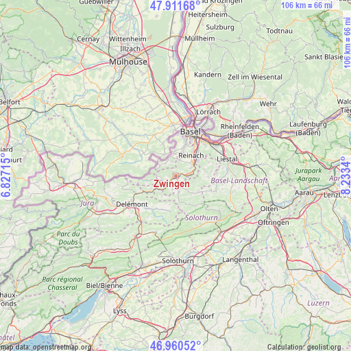
Zwingen GPS coordinates[2]
47° 26' 17.7" North, 7° 31' 48.972" East
| Map corner | latitude | longitude |
|---|---|---|
| Upper-left | 47.91168°, | 6.82715° |
| Center: | 47.43825°, | 7.53027° |
| Lower-right: | 46.96052°, | 8.2334° |
| Map W x H: | 105.8×105.8 km | = 65.7×65.7mi |
| max Lat: | 47.76737° ⇑19.4% North |
| Zwingen: | 47.43825° |
| min Lat: | ⇓80.6% South 45.83203° |
| min Long | Zwingen | max Long |
| 5.97153° | 7.53027° | 10.44624° |
| W 25.4%⇐ | ⇒74.6% E |
Elevation
Elevation of Zwingen is 342 m = 1122 ft, and this is 216.2 m = 709 ft below average elevation for this country.
| Max E: |
1845 m = 6053 ft | 95.5% |
| Avg. | 558.2 m = 1831 ft | |
| Zwingen | 342 m = 1122 ft | |
Min E: |
197 m = 646 ft | 4.5% |
See also: Switzerland elevation on elevation.city.
Geographical zone
Zwingen is located in North temperate zone (between Tropic of Cancer and the Arctic Circle). Distance of this North polar circle is 2126.5 km =1321.3 mi to North.| Distance of | km | miles | from Zwingen |
|---|---|---|---|
| North Pole | 4732.4 | 2940.6 | to North |
| Arctic Circle | 2126.5 | 1321.3 | to North |
| Tropic Cancer | 2668.7 | 1658.3 | to South |
| Equator | 5274.6 | 3277.5 | to South |


Nearby cities:
15 places around Zwingen: (largest is in red/bold)
• Aesch
6.2 km =3.9 mi,  54°
54°
• Blauen
1.5 km =0.9 mi,  327°
327°
• Breitenbach
3.7 km =2.3 mi,  161°
161°
• Brislach
2.5 km =1.6 mi, 156°
• Büsserach
5 km =3.1 mi,  170°
170°
• Erschwil
7.2 km =4.5 mi, 173°
• Ettingen
5 km =3.1 mi,  14°
14°
• Grellingen
4.4 km =2.7 mi,  84°
84°
• Himmelried
5.6 km =3.5 mi,  109°
109°
• Laufen
2.9 km =1.8 mi,  231°
231°
• Pfeffingen
5.1 km =3.2 mi,  61°
61°
• Rodersdorf
7.2 km =4.5 mi,  310°
310°
• Röschenz
4.1 km =2.5 mi,  246°
246°
• Therwil
7.1 km =4.4 mi,  16°
16°
• Wahlen
4.2 km =2.6 mi,  195°
195°
Sources, notices
• [Note1] Compared only with cities in Switzerland existing in our database
• [Src1] Map data: © OpenStreetMap contributors (CC-BY-SA)
• [Src2] Other city data from geonames.org with taken over terms of usage.
• [Src3] Geographical zone / Annual Mean Temperature by Robert A. Rohde @ Wikipedia
