Oberstammheim geodata
Oberstammheim (Zurich) is a populated place; located in Switzerland in Europe/Zurich (GMT+2) time zone. With population of 863 people, there are 1444 cities with bigger population in this country. Compared to other cities in Switzerland, 97.9% of cities are located further ↓South; 81.3% of cities are located further ←West and 64.5% of cities have higher elevation than Oberstammheim. Note1


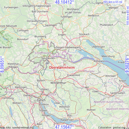
Oberstammheim GPS coordinates[2]
47° 37' 56.784" North, 8° 47' 58.668" East
| Map corner | latitude | longitude |
|---|---|---|
| Upper-left | 48.10412°, | 8.09651° |
| Center: | 47.63244°, | 8.79963° |
| Lower-right: | 47.15647°, | 9.50276° |
| Map W x H: | 105.4×105.4 km | = 65.5×65.5mi |
| max Lat: | 47.76737° ⇑2.1% North |
| Oberstammheim: | 47.63244° |
| min Lat: | ⇓97.9% South 45.83203° |
| min Long | Oberstammheim | max Long |
| 5.97153° | 8.79963° | 10.44624° |
| W 81.3%⇐ | ⇒18.7% E |
Elevation
Elevation of Oberstammheim is 447 m = 1467 ft, and this is 111.2 m = 365 ft below average elevation for this country.
| Max E: |
1845 m = 6053 ft | 64.5% |
| Avg. | 558.2 m = 1831 ft | |
| Oberstammheim | 447 m = 1467 ft | |
Min E: |
197 m = 646 ft | 35.5% |
See also: Switzerland elevation on elevation.city.
Geographical zone
Oberstammheim is located in North temperate zone (between Tropic of Cancer and the Arctic Circle). Distance of this North polar circle is 2104.9 km =1307.9 mi to North.| Distance of | km | miles | from Oberstammheim |
|---|---|---|---|
| North Pole | 4710.8 | 2927.2 | to North |
| Arctic Circle | 2104.9 | 1307.9 | to North |
| Tropic Cancer | 2690.3 | 1671.7 | to South |
| Equator | 5296.2 | 3290.9 | to South |


Nearby cities:
15 places around Oberstammheim: (largest is in red/bold)
• Diessenhofen
7.3 km =4.5 mi,  329°
329°
• Dinhard
8.9 km =5.5 mi,  196°
196°
• Eschenz
5.9 km =3.7 mi,  72°
72°
• Herdern
8.9 km =5.5 mi,  111°
111°
• Hüttwilen
6.2 km =3.9 mi,  117°
117°
• Kleinandelfingen
9.4 km =5.8 mi,  247°
247°
• Mammern
8.8 km =5.5 mi,  79°
79°
• Oberneuforn
3.9 km =2.4 mi,  218°
218°
• Ossingen
5.9 km =3.7 mi, 246°
• Ramsen
8.4 km =5.2 mi,  5°
5°
• Rickenbach
9 km =5.6 mi,  181°
181°
• Stein am Rhein
5.4 km =3.4 mi,  56°
56°
• Trüllikon
8.3 km =5.2 mi,  272°
272°
• Unterstammheim
1 km =0.6 mi,  318°
318°
• Wagenhausen
4.7 km =2.9 mi,  49°
49°
Sources, notices
• [Note1] Compared only with cities in Switzerland existing in our database
• [Src1] Map data: © OpenStreetMap contributors (CC-BY-SA)
• [Src2] Other city data from geonames.org with taken over terms of usage.
• [Src3] Geographical zone / Annual Mean Temperature by Robert A. Rohde @ Wikipedia
