Unterstammheim geodata
Unterstammheim (Zurich) is a populated place; located in Switzerland in Europe/Zurich (GMT+1) time zone. With population of 697 people, there are 1602 cities with bigger population in this country. Compared to other cities in Switzerland, 98.2% of cities are located further ↓South; 80.7% of cities are located further ←West and 64.5% of cities have higher elevation than Unterstammheim. Note1


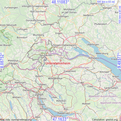
Unterstammheim GPS coordinates[2]
47° 38' 21.156" North, 8° 47' 26.304" East
| Map corner | latitude | longitude |
|---|---|---|
| Upper-left | 48.11083°, | 8.08752° |
| Center: | 47.63921°, | 8.79064° |
| Lower-right: | 47.1633°, | 9.49377° |
| Map W x H: | 105.4×105.4 km | = 65.5×65.5mi |
| max Lat: | 47.76737° ⇑1.8% North |
| Unterstammheim: | 47.63921° |
| min Lat: | ⇓98.2% South 45.83203° |
| min Long | Unterstammheim | max Long |
| 5.97153° | 8.79064° | 10.44624° |
| W 80.7%⇐ | ⇒19.3% E |
Elevation
Elevation of Unterstammheim is 447 m = 1467 ft, and this is 111.2 m = 365 ft below average elevation for this country.
| Max E: |
1845 m = 6053 ft | 64.5% |
| Avg. | 558.2 m = 1831 ft | |
| Unterstammheim | 447 m = 1467 ft | |
Min E: |
197 m = 646 ft | 35.5% |
See also: Switzerland elevation on elevation.city.
Geographical zone
Unterstammheim is located in North temperate zone (between Tropic of Cancer and the Arctic Circle). Distance of this North polar circle is 2104.2 km =1307.5 mi to North.| Distance of | km | miles | from Unterstammheim |
|---|---|---|---|
| North Pole | 4710.1 | 2926.7 | to North |
| Arctic Circle | 2104.2 | 1307.5 | to North |
| Tropic Cancer | 2691.1 | 1672.2 | to South |
| Equator | 5297 | 3291.4 | to South |


Nearby cities:
15 places around Unterstammheim: (largest is in red/bold)
• Diessenhofen
6.3 km =3.9 mi,  330°
330°
• Dinhard
9.5 km =5.9 mi,  190°
190°
• Dörflingen
9 km =5.6 mi, 325°
• Eschenz
6.4 km =4 mi,  81°
81°
• Hüttwilen
7.2 km =4.5 mi,  120°
120°
• Kleinandelfingen
9.1 km =5.7 mi,  241°
241°
• Mammern
9.4 km =5.8 mi,  85°
85°
• Oberneuforn
4.2 km =2.6 mi,  204°
204°
• Oberstammheim
1 km =0.6 mi,  138°
138°
• Ossingen
5.6 km =3.5 mi, 237°
• Ramsen
7.8 km =4.8 mi,  10°
10°
• Rickenbach
9.7 km =6 mi,  177°
177°
• Stein am Rhein
5.6 km =3.5 mi,  66°
66°
• Trüllikon
7.6 km =4.7 mi,  266°
266°
• Wagenhausen
4.9 km =3 mi,  61°
61°
Sources, notices
• [Note1] Compared only with cities in Switzerland existing in our database
• [Src1] Map data: © OpenStreetMap contributors (CC-BY-SA)
• [Src2] Other city data from geonames.org with taken over terms of usage.
• [Src3] Geographical zone / Annual Mean Temperature by Robert A. Rohde @ Wikipedia
