Oberentfelden geodata
Oberentfelden (Aargau) is a populated place; located in Switzerland in Europe/Zurich (GMT+2) time zone. With population of 7,553 people, there are 215 cities with bigger population in this country. Compared to other cities in Switzerland, 65.4% of cities are located further ↓South; 59.2% of cities are located further →East and 83.8% of cities have higher elevation than Oberentfelden. Note1


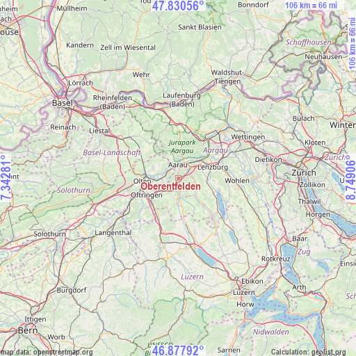
Oberentfelden GPS coordinates[2]
47° 21' 23.004" North, 8° 2' 45.384" East
| Map corner | latitude | longitude |
|---|---|---|
| Upper-left | 47.83056°, | 7.34281° |
| Center: | 47.35639°, | 8.04594° |
| Lower-right: | 46.87792°, | 8.74906° |
| Map W x H: | 105.9×105.9 km | = 65.8×65.8mi |
| max Lat: | 47.76737° ⇑34.6% North |
| Oberentfelden: | 47.35639° |
| min Lat: | ⇓65.4% South 45.83203° |
| min Long | Oberentfelden | max Long |
| 5.97153° | 8.04594° | 10.44624° |
| W 40.8%⇐ | ⇒59.2% E |
Elevation
Elevation of Oberentfelden is 413 m = 1355 ft, and this is 145.2 m = 476 ft below average elevation for this country.
| Max E: |
1845 m = 6053 ft | 83.8% |
| Avg. | 558.2 m = 1831 ft | |
| Oberentfelden | 413 m = 1355 ft | |
Min E: |
197 m = 646 ft | 16.2% |
See also: Switzerland elevation on elevation.city.
Geographical zone
Oberentfelden is located in North temperate zone (between Tropic of Cancer and the Arctic Circle). Distance of this North polar circle is 2135.6 km =1327 mi to North.| Distance of | km | miles | from Oberentfelden |
|---|---|---|---|
| North Pole | 4741.5 | 2946.2 | to North |
| Arctic Circle | 2135.6 | 1327 | to North |
| Tropic Cancer | 2659.6 | 1652.6 | to South |
| Equator | 5265.5 | 3271.8 | to South |


Nearby cities:
15 places around Oberentfelden: (largest is in red/bold)
• Aarau
4 km =2.5 mi,  358°
358°
• Buchs
5 km =3.1 mi,  33°
33°
• Erlinsbach
5.4 km =3.4 mi,  327°
327°
• Gränichen
4.3 km =2.7 mi,  85°
85°
• Kölliken
3.1 km =1.9 mi,  214°
214°
• Küttigen
6.5 km =4 mi,  2°
2°
• Muhen
2.4 km =1.5 mi,  162°
162°
• Niedergösgen
4.7 km =2.9 mi,  291°
291°
• Obergösgen
7.2 km =4.5 mi,  278°
278°
• Safenwil
6.1 km =3.8 mi,  231°
231°
• Schöftland
5.6 km =3.5 mi,  175°
175°
• Schönenwerd
3.6 km =2.2 mi, 292°
• Suhr
3.1 km =1.9 mi,  56°
56°
• Teufenthal
6.2 km =3.9 mi,  119°
119°
• Uerkheim
6.1 km =3.8 mi,  196°
196°
Sources, notices
• [Note1] Compared only with cities in Switzerland existing in our database
• [Src1] Map data: © OpenStreetMap contributors (CC-BY-SA)
• [Src2] Other city data from geonames.org with taken over terms of usage.
• [Src3] Geographical zone / Annual Mean Temperature by Robert A. Rohde @ Wikipedia
