Obergösgen geodata
Obergösgen (Solothurn) is a populated place; located in Switzerland in Europe/Zurich (GMT+2) time zone. With population of 2,076 people, there are 815 cities with bigger population in this country. Compared to other cities in Switzerland, 67% of cities are located further ↓South; 61.4% of cities are located further →East and 90.5% of cities have higher elevation than Obergösgen. Note1


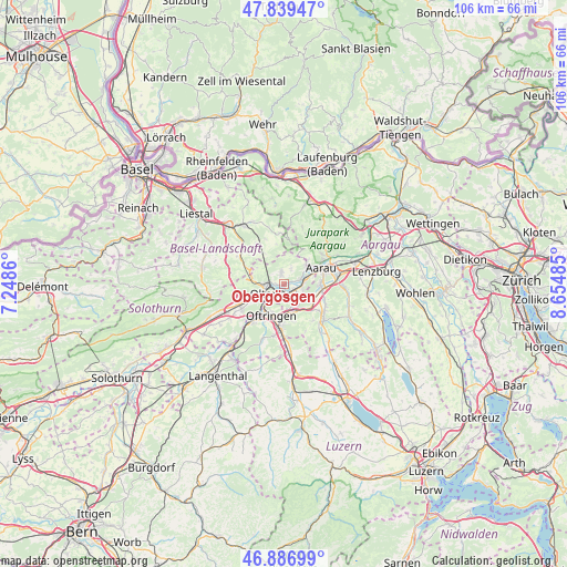
Obergösgen GPS coordinates[2]
47° 21' 55.368" North, 7° 57' 6.228" East
| Map corner | latitude | longitude |
|---|---|---|
| Upper-left | 47.83947°, | 7.2486° |
| Center: | 47.36538°, | 7.95173° |
| Lower-right: | 46.88699°, | 8.65485° |
| Map W x H: | 105.9×105.9 km | = 65.8×65.8mi |
| max Lat: | 47.76737° ⇑33% North |
| Obergösgen: | 47.36538° |
| min Lat: | ⇓67% South 45.83203° |
| min Long | Obergösgen | max Long |
| 5.97153° | 7.95173° | 10.44624° |
| W 38.6%⇐ | ⇒61.4% E |
Elevation
Elevation of Obergösgen is 392 m = 1286 ft, and this is 166.2 m = 545 ft below average elevation for this country.
| Max E: |
1845 m = 6053 ft | 90.5% |
| Avg. | 558.2 m = 1831 ft | |
| Obergösgen | 392 m = 1286 ft | |
Min E: |
197 m = 646 ft | 9.5% |
See also: Switzerland elevation on elevation.city.
Geographical zone
Obergösgen is located in North temperate zone (between Tropic of Cancer and the Arctic Circle). Distance of this North polar circle is 2134.6 km =1326.4 mi to North.| Distance of | km | miles | from Obergösgen |
|---|---|---|---|
| North Pole | 4740.5 | 2945.6 | to North |
| Arctic Circle | 2134.6 | 1326.4 | to North |
| Tropic Cancer | 2660.6 | 1653.2 | to South |
| Equator | 5266.5 | 3272.5 | to South |


Nearby cities:
15 places around Obergösgen: (largest is in red/bold)
• Aarau
7.6 km =4.7 mi,  66°
66°
• Aarburg
6.3 km =3.9 mi,  218°
218°
• Erlinsbach
5.5 km =3.4 mi,  49°
49°
• Kölliken
6.4 km =4 mi,  123°
123°
• Lostorf
2.1 km =1.3 mi,  349°
349°
• Niedergösgen
2.8 km =1.7 mi,  75°
75°
• Oberentfelden
7.2 km =4.5 mi,  98°
98°
• Oftringen
6.1 km =3.8 mi,  199°
199°
• Olten
4 km =2.5 mi,  244°
244°
• Rohr
5 km =3.1 mi,  1°
1°
• Safenwil
5.4 km =3.4 mi,  154°
154°
• Schönenwerd
3.8 km =2.4 mi, 83°
• Trimbach
4.9 km =3 mi,  270°
270°
• Wangen
6.6 km =4.1 mi,  248°
248°
• Zeglingen
6.7 km =4.2 mi,  329°
329°
Sources, notices
• [Note1] Compared only with cities in Switzerland existing in our database
• [Src1] Map data: © OpenStreetMap contributors (CC-BY-SA)
• [Src2] Other city data from geonames.org with taken over terms of usage.
• [Src3] Geographical zone / Annual Mean Temperature by Robert A. Rohde @ Wikipedia
