Erlinsbach geodata
Erlinsbach (Solothurn) is a populated place; located in Switzerland in Europe/Zurich (GMT+2) time zone. With population of 2,258 people, there are 755 cities with bigger population in this country. Compared to other cities in Switzerland, 73.3% of cities are located further ↓South; 60.1% of cities are located further →East and 88% of cities have higher elevation than Erlinsbach. Note1


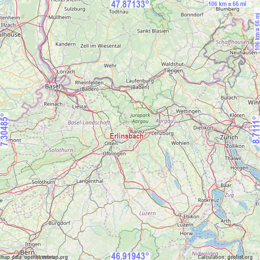
Erlinsbach GPS coordinates[2]
47° 23' 51.108" North, 8° 0' 28.692" East
| Map corner | latitude | longitude |
|---|---|---|
| Upper-left | 47.87133°, | 7.30485° |
| Center: | 47.39753°, | 8.00797° |
| Lower-right: | 46.91943°, | 8.7111° |
| Map W x H: | 105.8×105.8 km | = 65.7×65.7mi |
| max Lat: | 47.76737° ⇑26.7% North |
| Erlinsbach: | 47.39753° |
| min Lat: | ⇓73.3% South 45.83203° |
| min Long | Erlinsbach | max Long |
| 5.97153° | 8.00797° | 10.44624° |
| W 39.9%⇐ | ⇒60.1% E |
Elevation
Elevation of Erlinsbach is 402 m = 1319 ft, and this is 156.2 m = 512 ft below average elevation for this country.
| Max E: |
1845 m = 6053 ft | 88% |
| Avg. | 558.2 m = 1831 ft | |
| Erlinsbach | 402 m = 1319 ft | |
Min E: |
197 m = 646 ft | 12% |
See also: Switzerland elevation on elevation.city.
Geographical zone
Erlinsbach is located in North temperate zone (between Tropic of Cancer and the Arctic Circle). Distance of this North polar circle is 2131.1 km =1324.2 mi to North.| Distance of | km | miles | from Erlinsbach |
|---|---|---|---|
| North Pole | 4737 | 2943.4 | to North |
| Arctic Circle | 2131.1 | 1324.2 | to North |
| Tropic Cancer | 2664.2 | 1655.5 | to South |
| Equator | 5270.1 | 3274.7 | to South |


Nearby cities:
15 places around Erlinsbach: (largest is in red/bold)
• Aarau
2.8 km =1.7 mi,  101°
101°
• Biberstein
6.2 km =3.9 mi,  70°
70°
• Buchs
5.6 km =3.5 mi,  94°
94°
• Densbüren
7 km =4.3 mi,  29°
29°
• Kölliken
7.2 km =4.5 mi,  171°
171°
• Küttigen
3.7 km =2.3 mi,  58°
58°
• Lostorf
4.9 km =3 mi,  251°
251°
• Niedergösgen
3.2 km =2 mi,  207°
207°
• Oberentfelden
5.4 km =3.4 mi,  147°
147°
• Obergösgen
5.5 km =3.4 mi,  229°
229°
• Oberhof
5.7 km =3.5 mi,  356°
356°
• Rohr
4.3 km =2.7 mi,  289°
289°
• Schönenwerd
3.2 km =2 mi,  188°
188°
• Suhr
6.1 km =3.8 mi,  117°
117°
• Wölflinswil
7.1 km =4.4 mi,  354°
354°
Sources, notices
• [Note1] Compared only with cities in Switzerland existing in our database
• [Src1] Map data: © OpenStreetMap contributors (CC-BY-SA)
• [Src2] Other city data from geonames.org with taken over terms of usage.
• [Src3] Geographical zone / Annual Mean Temperature by Robert A. Rohde @ Wikipedia
