Aarau geodata
Aarau (Aargau) is a seat of a first-order administrative division; located in Switzerland in Europe/Zurich (GMT+2) time zone. With population of 15,501 people, there are 76 cities with bigger population in this country. Compared to other cities in Switzerland, 71.6% of cities are located further ↓South; 59.3% of cities are located further →East and 91.1% of cities have higher elevation than Aarau. Note1


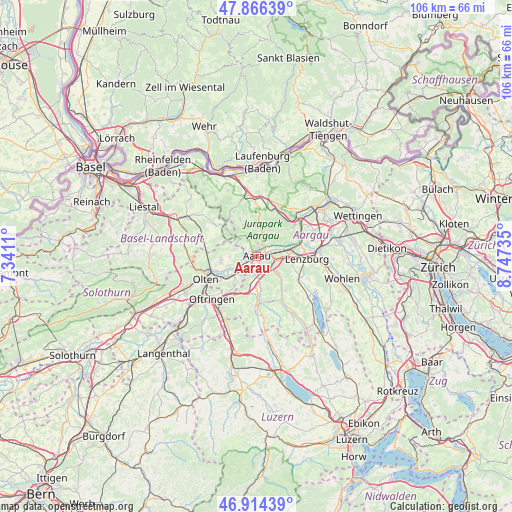
Aarau GPS coordinates[2]
47° 23' 33.144" North, 8° 2' 39.192" East
| Map corner | latitude | longitude |
|---|---|---|
| Upper-left | 47.86639°, | 7.3411° |
| Center: | 47.39254°, | 8.04422° |
| Lower-right: | 46.91439°, | 8.74735° |
| Map W x H: | 105.9×105.9 km | = 65.8×65.8mi |
| max Lat: | 47.76737° ⇑28.4% North |
| Aarau: | 47.39254° |
| min Lat: | ⇓71.6% South 45.83203° |
| min Long | Aarau | max Long |
| 5.97153° | 8.04422° | 10.44624° |
| W 40.7%⇐ | ⇒59.3% E |
Elevation
Elevation of Aarau is 389 m = 1276 ft, and this is 169.2 m = 555 ft below average elevation for this country.
| Max E: |
1845 m = 6053 ft | 91.1% |
| Avg. | 558.2 m = 1831 ft | |
| Aarau | 389 m = 1276 ft | |
Min E: |
197 m = 646 ft | 8.9% |
See also: Switzerland elevation on elevation.city.
Geographical zone
Aarau is located in North temperate zone (between Tropic of Cancer and the Arctic Circle). Distance of this North polar circle is 2131.6 km =1324.5 mi to North.| Distance of | km | miles | from Aarau |
|---|---|---|---|
| North Pole | 4737.5 | 2943.7 | to North |
| Arctic Circle | 2131.6 | 1324.5 | to North |
| Tropic Cancer | 2663.6 | 1655.1 | to South |
| Equator | 5269.6 | 3274.4 | to South |


Nearby cities:
15 places around Aarau: (largest is in red/bold)
• Biberstein
4.1 km =2.5 mi,  49°
49°
• Buchs
2.9 km =1.8 mi,  87°
87°
• Densbüren
6.7 km =4.2 mi,  5°
5°
• Erlinsbach
2.8 km =1.7 mi,  281°
281°
• Gränichen
5.7 km =3.5 mi,  130°
130°
• Kölliken
6.8 km =4.2 mi,  194°
194°
• Küttigen
2.5 km =1.6 mi, 9°
• Muhen
6.4 km =4 mi,  172°
172°
• Niedergösgen
4.8 km =3 mi,  240°
240°
• Oberentfelden
4 km =2.5 mi,  178°
178°
• Oberhof
7 km =4.3 mi,  333°
333°
• Rupperswil
6.4 km =4 mi,  81°
81°
• Schönenwerd
4.1 km =2.5 mi,  230°
230°
• Suhr
3.5 km =2.2 mi, 130°
• Thalheim
6.4 km =4 mi,  41°
41°
Sources, notices
• [Note1] Compared only with cities in Switzerland existing in our database
• [Src1] Map data: © OpenStreetMap contributors (CC-BY-SA)
• [Src2] Other city data from geonames.org with taken over terms of usage.
• [Src3] Geographical zone / Annual Mean Temperature by Robert A. Rohde @ Wikipedia
