Schwyz geodata
Schwyz is a seat of a first-order administrative division; located in Switzerland in Europe/Zurich (GMT+2) time zone. With population of 14,177 people, there are 90 cities with bigger population in this country. Compared to other cities in Switzerland, 63.4% of cities are located further ↑North; 70.6% of cities are located further ←West and 60.5% of cities have lower elevation than Schwyz. Note1


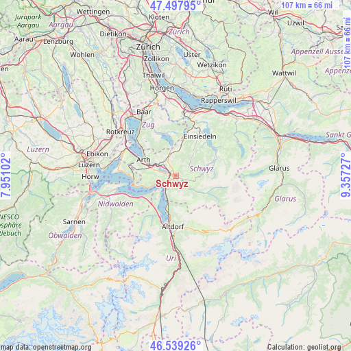
Schwyz GPS coordinates[2]
47° 1' 14.736" North, 8° 39' 14.904" East
| Map corner | latitude | longitude |
|---|---|---|
| Upper-left | 47.49795°, | 7.95102° |
| Center: | 47.02076°, | 8.65414° |
| Lower-right: | 46.53926°, | 9.35727° |
| Map W x H: | 106.6×106.6 km | = 66.2×66.2mi |
| max Lat: | 47.76737° ⇑63.4% North |
| Schwyz: | 47.02076° |
| min Lat: | ⇓36.6% South 45.83203° |
| min Long | Schwyz | max Long |
| 5.97153° | 8.65414° | 10.44624° |
| W 70.6%⇐ | ⇒29.4% E |
Elevation
Elevation of Schwyz is 521 m = 1709 ft, and this is 37.2 m = 122 ft below average elevation for this country.
| Max E: |
1845 m = 6053 ft | 39.5% |
| Avg. | 558.2 m = 1831 ft | |
| Schwyz | 521 m = 1709 ft | |
Min E: |
197 m = 646 ft | 60.5% |
See also: Switzerland elevation on elevation.city.
Geographical zone
Schwyz is located in North temperate zone (between Tropic of Cancer and the Arctic Circle). Distance of this North polar circle is 2173 km =1350.2 mi to North.| Distance of | km | miles | from Schwyz |
|---|---|---|---|
| North Pole | 4778.8 | 2969.4 | to North |
| Arctic Circle | 2173 | 1350.2 | to North |
| Tropic Cancer | 2622.3 | 1629.4 | to South |
| Equator | 5228.2 | 3248.7 | to South |


Nearby cities:
15 places around Schwyz: (largest is in red/bold)
• Alpthal
7.2 km =4.5 mi,  40°
40°
• Gersau
10.2 km =6.3 mi,  253°
253°
• Goldau
8.7 km =5.4 mi,  290°
290°
• Ibach
1.3 km =0.8 mi,  211°
211°
• Illgau
6.5 km =4 mi,  124°
124°
• Ingenbohl
3.8 km =2.4 mi,  230°
230°
• Lauerz
5.5 km =3.4 mi,  284°
284°
• Morschach
5 km =3.1 mi, 212°
• Muotathal
9.7 km =6 mi, 120°
• Oberiberg
9.7 km =6 mi,  78°
78°
• Rothenthurm
9.4 km =5.8 mi,  10°
10°
• Sattel
7 km =4.3 mi,  348°
348°
• Seelisberg
7.4 km =4.6 mi,  223°
223°
• Steinen
4.5 km =2.8 mi,  315°
315°
• Steinerberg
6.4 km =4 mi,  306°
306°
Sources, notices
• [Note1] Compared only with cities in Switzerland existing in our database
• [Src1] Map data: © OpenStreetMap contributors (CC-BY-SA)
• [Src2] Other city data from geonames.org with taken over terms of usage.
• [Src3] Geographical zone / Annual Mean Temperature by Robert A. Rohde @ Wikipedia
