Lützelflüh geodata
Lützelflüh (Bern) is a populated place; located in Switzerland in Europe/Zurich (GMT+2) time zone. With population of 4,035 people, there are 436 cities with bigger population in this country. Compared to other cities in Switzerland, 64.2% of cities are located further ↑North; 68.6% of cities are located further →East and 74.1% of cities have lower elevation than Lützelflüh. Note1


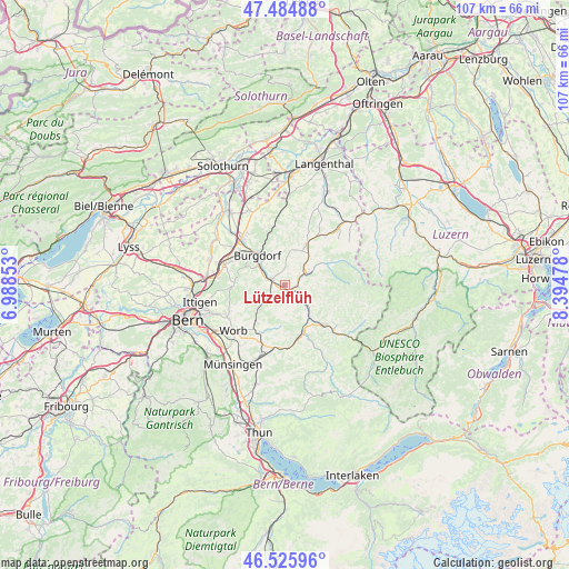
Lützelflüh GPS coordinates[2]
47° 0' 27.252" North, 7° 41' 29.94" East
| Map corner | latitude | longitude |
|---|---|---|
| Upper-left | 47.48488°, | 6.98853° |
| Center: | 47.00757°, | 7.69165° |
| Lower-right: | 46.52596°, | 8.39478° |
| Map W x H: | 106.6×106.6 km | = 66.2×66.2mi |
| max Lat: | 47.76737° ⇑64.2% North |
| Lützelflüh: | 47.00757° |
| min Lat: | ⇓35.8% South 45.83203° |
| min Long | Lützelflüh | max Long |
| 5.97153° | 7.69165° | 10.44624° |
| W 31.4%⇐ | ⇒68.6% E |
Elevation
Elevation of Lützelflüh is 608 m = 1995 ft, and this is 49.8 m = 163 ft above average elevation for this country.
| Max E: |
1845 m = 6053 ft | 25.9% |
| Lützelflüh | 608 m 1995 ft | |
| Avg. | 558.2 m = 1831 ft | |
Min E: |
197 m = 646 ft | 74.1% |
See also: Switzerland elevation on elevation.city.
Geographical zone
Lützelflüh is located in North temperate zone (between Tropic of Cancer and the Arctic Circle). Distance of this North polar circle is 2174.4 km =1351.1 mi to North.| Distance of | km | miles | from Lützelflüh |
|---|---|---|---|
| North Pole | 4780.3 | 2970.3 | to North |
| Arctic Circle | 2174.4 | 1351.1 | to North |
| Tropic Cancer | 2620.8 | 1628.5 | to South |
| Equator | 5226.8 | 3247.8 | to South |


Nearby cities:
15 places around Lützelflüh: (largest is in red/bold)
• Arni
8.3 km =5.2 mi,  194°
194°
• Biglen
10.4 km =6.5 mi,  209°
209°
• Burgdorf
7.5 km =4.7 mi,  319°
319°
• Heimiswil
6.9 km =4.3 mi,  344°
344°
• Krauchthal
9.5 km =5.9 mi,  271°
271°
• Landiswil
5.6 km =3.5 mi, 189°
• Lauperswil
6 km =3.7 mi,  140°
140°
• Oberburg
5.8 km =3.6 mi,  303°
303°
• Rüderswil
3.5 km =2.2 mi, 139°
• Rüegsau
2.3 km =1.4 mi,  325°
325°
• Rüti bei Lyssach
10.3 km =6.4 mi, 302°
• Signau
10.1 km =6.3 mi,  165°
165°
• Sumiswald
4.6 km =2.9 mi,  61°
61°
• Trachselwald
3.5 km =2.2 mi,  72°
72°
• Walkringen
8.5 km =5.3 mi,  219°
219°
Sources, notices
• [Note1] Compared only with cities in Switzerland existing in our database
• [Src1] Map data: © OpenStreetMap contributors (CC-BY-SA)
• [Src2] Other city data from geonames.org with taken over terms of usage.
• [Src3] Geographical zone / Annual Mean Temperature by Robert A. Rohde @ Wikipedia
