Lauperswil geodata
Lauperswil (Bern) is a populated place; located in Switzerland in Europe/Zurich (GMT+2) time zone. With population of 2,700 people, there are 654 cities with bigger population in this country. Compared to other cities in Switzerland, 66.2% of cities are located further ↑North; 67.2% of cities are located further →East and 78.2% of cities have lower elevation than Lauperswil. Note1


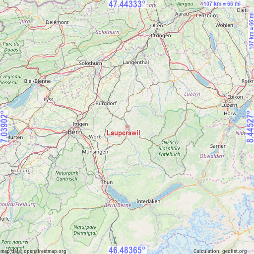
Lauperswil GPS coordinates[2]
46° 57' 56.304" North, 7° 44' 31.704" East
| Map corner | latitude | longitude |
|---|---|---|
| Upper-left | 47.44333°, | 7.03902° |
| Center: | 46.96564°, | 7.74214° |
| Lower-right: | 46.48365°, | 8.44527° |
| Map W x H: | 106.7×106.7 km | = 66.3×66.3mi |
| max Lat: | 47.76737° ⇑66.2% North |
| Lauperswil: | 46.96564° |
| min Lat: | ⇓33.8% South 45.83203° |
| min Long | Lauperswil | max Long |
| 5.97153° | 7.74214° | 10.44624° |
| W 32.8%⇐ | ⇒67.2% E |
Elevation
Elevation of Lauperswil is 643 m = 2110 ft, and this is 84.8 m = 278 ft above average elevation for this country.
| Max E: |
1845 m = 6053 ft | 21.8% |
| Lauperswil | 643 m 2110 ft | |
| Avg. | 558.2 m = 1831 ft | |
Min E: |
197 m = 646 ft | 78.2% |
See also: Switzerland elevation on elevation.city.
Geographical zone
Lauperswil is located in North temperate zone (between Tropic of Cancer and the Arctic Circle). Distance of this North polar circle is 2179.1 km =1354 mi to North.| Distance of | km | miles | from Lauperswil |
|---|---|---|---|
| North Pole | 4785 | 2973.3 | to North |
| Arctic Circle | 2179.1 | 1354 | to North |
| Tropic Cancer | 2616.2 | 1625.6 | to South |
| Equator | 5222.1 | 3244.9 | to South |


Nearby cities:
15 places around Lauperswil: (largest is in red/bold)
• Arni
6.8 km =4.2 mi,  240°
240°
• Biglen
9.9 km =6.2 mi, 243°
• Bowil
8.8 km =5.5 mi,  202°
202°
• Landiswil
4.8 km =3 mi,  259°
259°
• Langnau
4.5 km =2.8 mi,  130°
130°
• Lützelflüh
6 km =3.7 mi,  320°
320°
• Rüderswil
2.5 km =1.6 mi, 322°
• Rüegsau
8.4 km =5.2 mi, 321°
• Signau
5.3 km =3.3 mi,  194°
194°
• Sumiswald
6.9 km =4.3 mi,  1°
1°
• Trachselwald
5.7 km =3.5 mi,  355°
355°
• Trub
10.8 km =6.7 mi,  104°
104°
• Trubschachen
9.2 km =5.7 mi,  121°
121°
• Walkringen
9.4 km =5.8 mi, 258°
• Zäziwil
9.3 km =5.8 mi,  220°
220°
Sources, notices
• [Note1] Compared only with cities in Switzerland existing in our database
• [Src1] Map data: © OpenStreetMap contributors (CC-BY-SA)
• [Src2] Other city data from geonames.org with taken over terms of usage.
• [Src3] Geographical zone / Annual Mean Temperature by Robert A. Rohde @ Wikipedia
