Rüegsau geodata
Rüegsau (Bern) is a seat of a third-order administrative division; located in Switzerland in Europe/Zurich (GMT+2) time zone. In our database, there are 1823 cities with bigger population. Compared to other cities in Switzerland, 63.2% of cities are located further ↑North; 69% of cities are located further →East and 81% of cities have lower elevation than Rüegsau. Note1


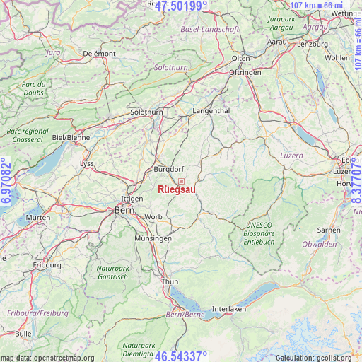
Rüegsau GPS coordinates[2]
47° 1' 29.388" North, 7° 40' 26.22" East
| Map corner | latitude | longitude |
|---|---|---|
| Upper-left | 47.50199°, | 6.97082° |
| Center: | 47.02483°, | 7.67395° |
| Lower-right: | 46.54337°, | 8.37707° |
| Map W x H: | 106.6×106.6 km | = 66.2×66.2mi |
| max Lat: | 47.76737° ⇑63.2% North |
| Rüegsau: | 47.02483° |
| min Lat: | ⇓36.8% South 45.83203° |
| min Long | Rüegsau | max Long |
| 5.97153° | 7.67395° | 10.44624° |
| W 31%⇐ | ⇒69% E |
Elevation
Elevation of Rüegsau is 675 m = 2215 ft, and this is 116.8 m = 383 ft above average elevation for this country.
| Max E: |
1845 m = 6053 ft | 19% |
| Rüegsau | 675 m 2215 ft | |
| Avg. | 558.2 m = 1831 ft | |
Min E: |
197 m = 646 ft | 81% |
See also: Switzerland elevation on elevation.city.
Geographical zone
Rüegsau is located in North temperate zone (between Tropic of Cancer and the Arctic Circle). Distance of this North polar circle is 2172.5 km =1349.9 mi to North.| Distance of | km | miles | from Rüegsau |
|---|---|---|---|
| North Pole | 4778.4 | 2969.2 | to North |
| Arctic Circle | 2172.5 | 1349.9 | to North |
| Tropic Cancer | 2622.8 | 1629.7 | to South |
| Equator | 5228.7 | 3249 | to South |


Nearby cities:
15 places around Rüegsau: (largest is in red/bold)
• Burgdorf
5.2 km =3.2 mi,  317°
317°
• Heimiswil
4.8 km =3 mi,  353°
353°
• Kirchberg
9.6 km =6 mi,  314°
314°
• Krauchthal
8.3 km =5.2 mi,  258°
258°
• Landiswil
7.4 km =4.6 mi,  176°
176°
• Lauperswil
8.4 km =5.2 mi,  141°
141°
• Lyssach
8.2 km =5.1 mi,  302°
302°
• Lützelflüh
2.3 km =1.4 mi,  145°
145°
• Oberburg
3.8 km =2.4 mi,  290°
290°
• Rüderswil
5.8 km =3.6 mi, 141°
• Rüti bei Lyssach
8.2 km =5.1 mi, 295°
• Sumiswald
5.4 km =3.4 mi,  86°
86°
• Trachselwald
4.8 km =3 mi,  100°
100°
• Walkringen
9.4 km =5.8 mi,  205°
205°
• Wynigen
9 km =5.6 mi,  356°
356°
Sources, notices
• [Note1] Compared only with cities in Switzerland existing in our database
• [Src1] Map data: © OpenStreetMap contributors (CC-BY-SA)
• [Src2] Other city data from geonames.org with taken over terms of usage.
• [Src3] Geographical zone / Annual Mean Temperature by Robert A. Rohde @ Wikipedia
