Gerlafingen geodata
Gerlafingen (Solothurn) is a populated place; located in Switzerland in Europe/Zurich (GMT+2) time zone. With population of 4,864 people, there are 355 cities with bigger population in this country. Compared to other cities in Switzerland, 55.1% of cities are located further ↑North; 72.8% of cities are located further →East and 62.2% of cities have higher elevation than Gerlafingen. Note1


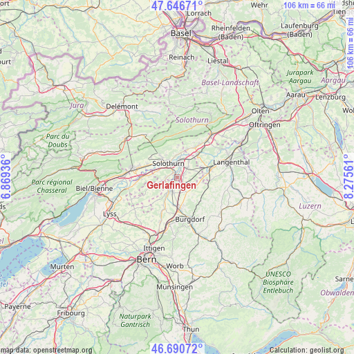
Gerlafingen GPS coordinates[2]
47° 10' 15.132" North, 7° 34' 20.964" East
| Map corner | latitude | longitude |
|---|---|---|
| Upper-left | 47.64671°, | 6.86936° |
| Center: | 47.17087°, | 7.57249° |
| Lower-right: | 46.69072°, | 8.27561° |
| Map W x H: | 106.3×106.3 km | = 66.1×66.1mi |
| max Lat: | 47.76737° ⇑55.1% North |
| Gerlafingen: | 47.17087° |
| min Lat: | ⇓44.9% South 45.83203° |
| min Long | Gerlafingen | max Long |
| 5.97153° | 7.57249° | 10.44624° |
| W 27.2%⇐ | ⇒72.8% E |
Elevation
Elevation of Gerlafingen is 451 m = 1480 ft, and this is 107.2 m = 352 ft below average elevation for this country.
| Max E: |
1845 m = 6053 ft | 62.2% |
| Avg. | 558.2 m = 1831 ft | |
| Gerlafingen | 451 m = 1480 ft | |
Min E: |
197 m = 646 ft | 37.8% |
See also: Switzerland elevation on elevation.city.
Geographical zone
Gerlafingen is located in North temperate zone (between Tropic of Cancer and the Arctic Circle). Distance of this North polar circle is 2156.3 km =1339.9 mi to North.| Distance of | km | miles | from Gerlafingen |
|---|---|---|---|
| North Pole | 4762.2 | 2959.1 | to North |
| Arctic Circle | 2156.3 | 1339.9 | to North |
| Tropic Cancer | 2639 | 1639.8 | to South |
| Equator | 5244.9 | 3259 | to South |


Nearby cities:
15 places around Gerlafingen: (largest is in red/bold)
• Alchenstorf
7 km =4.3 mi,  136°
136°
• Biberist
1.3 km =0.8 mi,  323°
323°
• Bätterkinden
5.1 km =3.2 mi,  210°
210°
• Deitingen
6 km =3.7 mi,  35°
35°
• Derendingen
3.3 km =2.1 mi,  21°
21°
• Koppigen
5.1 km =3.2 mi,  150°
150°
• Kriegstetten
2 km =1.2 mi,  78°
78°
• Langendorf
7 km =4.3 mi, 321°
• Luterbach
4.9 km =3 mi,  10°
10°
• Riedholz
6.8 km =4.2 mi,  357°
357°
• Seeberg
7.2 km =4.5 mi,  103°
103°
• Solothurn
4.9 km =3 mi,  327°
327°
• Subingen
4.7 km =2.9 mi,  49°
49°
• Utzenstorf
4.5 km =2.8 mi,  198°
198°
• Zuchwil
3.5 km =2.2 mi,  352°
352°
Sources, notices
• [Note1] Compared only with cities in Switzerland existing in our database
• [Src1] Map data: © OpenStreetMap contributors (CC-BY-SA)
• [Src2] Other city data from geonames.org with taken over terms of usage.
• [Src3] Geographical zone / Annual Mean Temperature by Robert A. Rohde @ Wikipedia
