Solothurn geodata
Solothurn is a seat of a first-order administrative division; located in Switzerland in Europe/Zurich (GMT+2) time zone. With population of 14,853 people, there are 84 cities with bigger population in this country. Compared to other cities in Switzerland, 51.9% of cities are located further ↑North; 74.4% of cities are located further →East and 69.1% of cities have higher elevation than Solothurn. Note1


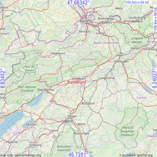
Solothurn GPS coordinates[2]
47° 12' 28.476" North, 7° 32' 13.704" East
| Map corner | latitude | longitude |
|---|---|---|
| Upper-left | 47.68342°, | 6.83402° |
| Center: | 47.20791°, | 7.53714° |
| Lower-right: | 46.7281°, | 8.24027° |
| Map W x H: | 106.2×106.2 km | = 66×66mi |
| max Lat: | 47.76737° ⇑51.9% North |
| Solothurn: | 47.20791° |
| min Lat: | ⇓48.1% South 45.83203° |
| min Long | Solothurn | max Long |
| 5.97153° | 7.53714° | 10.44624° |
| W 25.6%⇐ | ⇒74.4% E |
Elevation
Elevation of Solothurn is 440 m = 1444 ft, and this is 118.2 m = 388 ft below average elevation for this country.
| Max E: |
1845 m = 6053 ft | 69.1% |
| Avg. | 558.2 m = 1831 ft | |
| Solothurn | 440 m = 1444 ft | |
Min E: |
197 m = 646 ft | 30.9% |
See also: Switzerland elevation on elevation.city.
Geographical zone
Solothurn is located in North temperate zone (between Tropic of Cancer and the Arctic Circle). Distance of this North polar circle is 2152.1 km =1337.3 mi to North.| Distance of | km | miles | from Solothurn |
|---|---|---|---|
| North Pole | 4758 | 2956.5 | to North |
| Arctic Circle | 2152.1 | 1337.3 | to North |
| Tropic Cancer | 2643.1 | 1642.3 | to South |
| Equator | 5249 | 3261.6 | to South |


Nearby cities:
15 places around Solothurn: (largest is in red/bold)
• Attiswil
7.2 km =4.5 mi,  53°
53°
• Biberist
3.6 km =2.2 mi,  148°
148°
• Deitingen
6.2 km =3.9 mi,  82°
82°
• Derendingen
4 km =2.5 mi,  105°
105°
• Gerlafingen
4.9 km =3 mi, 147°
• Kriegstetten
5.9 km =3.7 mi,  128°
128°
• Langendorf
2.1 km =1.3 mi,  307°
307°
• Leuzigen
7.1 km =4.4 mi,  238°
238°
• Luterbach
3.7 km =2.3 mi, 78°
• Riedholz
3.5 km =2.2 mi,  41°
41°
• Selzach
6.2 km =3.9 mi,  267°
267°
• Subingen
6.3 km =3.9 mi,  99°
99°
• Utzenstorf
8.5 km =5.3 mi,  171°
171°
• Welschenrohr
8.1 km =5 mi,  354°
354°
• Zuchwil
2.3 km =1.4 mi, 107°
In other languages:
- In Spanish: Soleura
- In France: Soleure
- In Italian: Soletta
- In Russian: Золотурн
- In Chinese: 索洛图恩
Sources, notices
• [Note1] Compared only with cities in Switzerland existing in our database
• [Src1] Map data: © OpenStreetMap contributors (CC-BY-SA)
• [Src2] Other city data from geonames.org with taken over terms of usage.
• [Src3] Geographical zone / Annual Mean Temperature by Robert A. Rohde @ Wikipedia
