Bettlach geodata
Bettlach (Solothurn) is a populated place; located in Switzerland in Europe/Zurich (GMT+2) time zone. With population of 4,834 people, there are 360 cities with bigger population in this country. Compared to other cities in Switzerland, 52.6% of cities are located further ↑North; 77.3% of cities are located further →East and 54.2% of cities have higher elevation than Bettlach. Note1


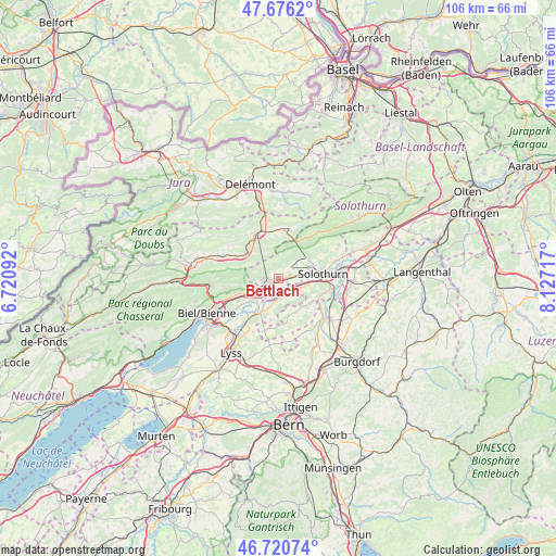
Bettlach GPS coordinates[2]
47° 12' 2.232" North, 7° 25' 26.58" East
| Map corner | latitude | longitude |
|---|---|---|
| Upper-left | 47.6762°, | 6.72092° |
| Center: | 47.20062°, | 7.42405° |
| Lower-right: | 46.72074°, | 8.12717° |
| Map W x H: | 106.2×106.2 km | = 66×66mi |
| max Lat: | 47.76737° ⇑52.6% North |
| Bettlach: | 47.20062° |
| min Lat: | ⇓47.4% South 45.83203° |
| min Long | Bettlach | max Long |
| 5.97153° | 7.42405° | 10.44624° |
| W 22.7%⇐ | ⇒77.3% E |
Elevation
Elevation of Bettlach is 469 m = 1539 ft, and this is 89.2 m = 293 ft below average elevation for this country.
| Max E: |
1845 m = 6053 ft | 54.2% |
| Avg. | 558.2 m = 1831 ft | |
| Bettlach | 469 m = 1539 ft | |
Min E: |
197 m = 646 ft | 45.8% |
See also: Switzerland elevation on elevation.city.
Geographical zone
Bettlach is located in North temperate zone (between Tropic of Cancer and the Arctic Circle). Distance of this North polar circle is 2153 km =1337.8 mi to North.| Distance of | km | miles | from Bettlach |
|---|---|---|---|
| North Pole | 4758.8 | 2957 | to North |
| Arctic Circle | 2153 | 1337.8 | to North |
| Tropic Cancer | 2642.3 | 1641.8 | to South |
| Equator | 5248.2 | 3261.1 | to South |


Nearby cities:
15 places around Bettlach: (largest is in red/bold)
• Arch
4 km =2.5 mi,  171°
171°
• Büren an der Aare
7.8 km =4.8 mi,  210°
210°
• Court
7.9 km =4.9 mi,  303°
303°
• Crémines
9.3 km =5.8 mi,  7°
7°
• Grenchen
2.3 km =1.4 mi,  246°
246°
• Langendorf
7.2 km =4.5 mi,  72°
72°
• Lengnau
4.7 km =2.9 mi,  243°
243°
• Leuzigen
3.9 km =2.4 mi,  138°
138°
• Meinisberg
7.3 km =4.5 mi,  231°
231°
• Moutier
9.6 km =6 mi,  334°
334°
• Perrefitte
10.4 km =6.5 mi,  323°
323°
• Pieterlen
7.1 km =4.4 mi, 246°
• Schnottwil
10.1 km =6.3 mi,  193°
193°
• Selzach
2.4 km =1.5 mi,  77°
77°
• Solothurn
8.6 km =5.3 mi, 84°
Sources, notices
• [Note1] Compared only with cities in Switzerland existing in our database
• [Src1] Map data: © OpenStreetMap contributors (CC-BY-SA)
• [Src2] Other city data from geonames.org with taken over terms of usage.
• [Src3] Geographical zone / Annual Mean Temperature by Robert A. Rohde @ Wikipedia
