La Chaux-de-Fonds geodata
La Chaux-de-Fonds (Neuchâtel) is a seat of a second-order administrative division; located in Switzerland in Europe/Zurich (GMT+2) time zone. With population of 36,825 people, there are 15 cities with bigger population in this country. Compared to other cities in Switzerland, 58.9% of cities are located further ↑North; 91.1% of cities are located further →East and 94.6% of cities have lower elevation than La Chaux-de-Fonds. Note1
Administrative division(s):
- Level 1: Neuchâtel
- Level 2: La Chaux-de-Fonds District
- Level 3: La Chaux-de-Fonds


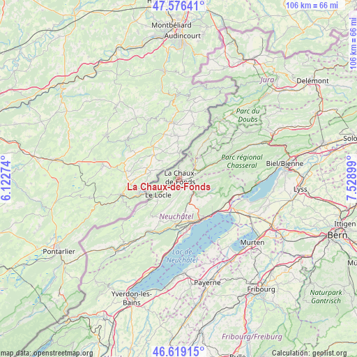
La Chaux-de-Fonds GPS coordinates[2]
47° 5' 59.748" North, 6° 49' 33.096" East
| Map corner | latitude | longitude |
|---|---|---|
| Upper-left | 47.57641°, | 6.12274° |
| Center: | 47.09993°, | 6.82586° |
| Lower-right: | 46.61915°, | 7.52899° |
| Map W x H: | 106.4×106.4 km | = 66.1×66.1mi |
| max Lat: | 47.76737° ⇑58.9% North |
| La Chaux-de-Fonds: | 47.09993° |
| min Lat: | ⇓41.1% South 45.83203° |
| min Long | La Chaux-de-Fon | max Long |
| 5.97153° | 6.82586° | 10.44624° |
| W 8.9%⇐ | ⇒91.1% E |
Elevation
Elevation of La Chaux-de-Fonds is 995 m = 3264 ft, and this is 436.8 m = 1433 ft above average elevation for this country.
| Max E: |
1845 m = 6053 ft | 5.4% |
| La Chaux-de-Fonds | 995 m 3264 ft | |
| Avg. | 558.2 m = 1831 ft | |
Min E: |
197 m = 646 ft | 94.6% |
See also: Switzerland elevation on elevation.city.
Geographical zone
La Chaux-de-Fonds is located in North temperate zone (between Tropic of Cancer and the Arctic Circle). Distance of this North polar circle is 2164.2 km =1344.8 mi to North.| Distance of | km | miles | from La Chaux-de-Fonds |
|---|---|---|---|
| North Pole | 4770 | 2963.9 | to North |
| Arctic Circle | 2164.2 | 1344.8 | to North |
| Tropic Cancer | 2631.1 | 1634.9 | to South |
| Equator | 5237 | 3254.1 | to South |


Nearby cities:
15 places around La Chaux-de-Fonds: (largest is in red/bold)
• Boudevilliers
9.4 km =5.8 mi,  149°
149°
• Cernier
7.3 km =4.5 mi,  129°
129°
• Chézard-Saint-Martin
9 km =5.6 mi,  114°
114°
• Dombresson
10.6 km =6.6 mi, 107°
• Fontainemelon
6.8 km =4.2 mi,  137°
137°
• Grand-Savagnier
11.2 km =7 mi,  119°
119°
• La Sagne
6.1 km =3.8 mi,  191°
191°
• Le Locle
7.6 km =4.7 mi,  230°
230°
• Les Bois
10.5 km =6.5 mi,  34°
34°
• Les Brenets
9.8 km =6.1 mi,  248°
248°
• Les Geneveys-sur-Coffrane
9.6 km =6 mi,  168°
168°
• Les Ponts-de-Martel
13.5 km =8.4 mi,  212°
212°
• Peseux
13.4 km =8.3 mi,  159°
159°
• Rochefort
13.7 km =8.5 mi, 185°
• Saint-Imier
14.2 km =8.8 mi,  65°
65°
Sources, notices
• [Note1] Compared only with cities in Switzerland existing in our database
• [Src1] Map data: © OpenStreetMap contributors (CC-BY-SA)
• [Src2] Other city data from geonames.org with taken over terms of usage.
• [Src3] Geographical zone / Annual Mean Temperature by Robert A. Rohde @ Wikipedia
