Les Geneveys-sur-Coffrane geodata
Les Geneveys-sur-Coffrane (Neuchâtel) is a populated place; located in Switzerland in Europe/Zurich (GMT+2) time zone. With population of 1,458 people, there are 1054 cities with bigger population in this country. Compared to other cities in Switzerland, 63.8% of cities are located further ↑North; 90.5% of cities are located further →East and 91.3% of cities have lower elevation than Les Geneveys-sur-Coffrane. Note1
Current local time in Les Geneveys-sur-Coffrane:
07:36 AM, SaturdayDifference from your time zone: hours


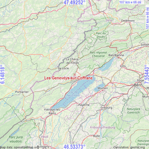
Les Geneveys-sur-Coffrane GPS coordinates[2]
47° 0' 55.008" North, 6° 51' 4.68" East
| Map corner | latitude | longitude |
|---|---|---|
| Upper-left | 47.49252°, | 6.14818° |
| Center: | 47.01528°, | 6.8513° |
| Lower-right: | 46.53373°, | 7.55443° |
| Map W x H: | 106.6×106.6 km | = 66.2×66.2mi |
| max Lat: | 47.76737° ⇑63.8% North |
| Les Geneveys-sur-Coffrane: | 47.01528° |
| min Lat: | ⇓36.2% South 45.83203° |
| min Long | Les Geneveys-su | max Long |
| 5.97153° | 6.8513° | 10.44624° |
| W 9.5%⇐ | ⇒90.5% E |
Elevation
Elevation of Les Geneveys-sur-Coffrane is 856 m = 2808 ft, and this is 297.8 m = 977 ft above average elevation for this country.
| Max E: |
1845 m = 6053 ft | 8.7% |
| Les Geneveys-sur-Coffrane | 856 m 2808 ft | |
| Avg. | 558.2 m = 1831 ft | |
Min E: |
197 m = 646 ft | 91.3% |
See also: Switzerland elevation on elevation.city.
Geographical zone
Les Geneveys-sur-Coffrane is located in North temperate zone (between Tropic of Cancer and the Arctic Circle). Distance of this North polar circle is 2173.6 km =1350.6 mi to North.| Distance of | km | miles | from Les Geneveys-sur-Coffrane |
|---|---|---|---|
| North Pole | 4779.5 | 2969.8 | to North |
| Arctic Circle | 2173.6 | 1350.6 | to North |
| Tropic Cancer | 2621.7 | 1629 | to South |
| Equator | 5227.6 | 3248.3 | to South |


Nearby cities:
15 places around Les Geneveys-sur-Coffrane: (largest is in red/bold)
• Auvernier
4.9 km =3 mi,  154°
154°
• Boudevilliers
3.2 km =2 mi,  65°
65°
• Boudry
7.3 km =4.5 mi,  188°
188°
• Cernier
6.1 km =3.8 mi,  37°
37°
• Chézard-Saint-Martin
8.4 km =5.2 mi,  47°
47°
• Cortaillod
8 km =5 mi,  183°
183°
• Fontainemelon
5.2 km =3.2 mi,  31°
31°
• Grand-Savagnier
8.8 km =5.5 mi,  63°
63°
• La Chaux-de-Fonds
9.6 km =6 mi,  348°
348°
• La Sagne
4.7 km =2.9 mi,  317°
317°
• Le Locle
9 km =5.6 mi,  300°
300°
• Les Ponts-de-Martel
9.4 km =5.8 mi,  257°
257°
• Neuchâtel
6.6 km =4.1 mi,  113°
113°
• Peseux
4.2 km =2.6 mi,  137°
137°
• Rochefort
5.3 km =3.3 mi,  217°
217°
Sources, notices
• [Note1] Compared only with cities in Switzerland existing in our database
• [Src1] Map data: © OpenStreetMap contributors (CC-BY-SA)
• [Src2] Other city data from geonames.org with taken over terms of usage.
• [Src3] Geographical zone / Annual Mean Temperature by Robert A. Rohde @ Wikipedia
