La Sagne geodata
La Sagne (Neuchâtel) is a populated place; located in Switzerland in Europe/Zurich (GMT+2) time zone. With population of 988 people, there are 1336 cities with bigger population in this country. Compared to other cities in Switzerland, 62.1% of cities are located further ↑North; 91.4% of cities are located further →East and 95.5% of cities have lower elevation than La Sagne. Note1
Administrative division(s):
- Level 1: Neuchâtel
- Level 2: La Chaux-de-Fonds District
- Level 3: La Sagne


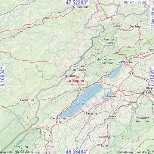
La Sagne GPS coordinates[2]
47° 2' 45.276" North, 6° 48' 34.056" East
| Map corner | latitude | longitude |
|---|---|---|
| Upper-left | 47.52288°, | 6.10634° |
| Center: | 47.04591°, | 6.80946° |
| Lower-right: | 46.56464°, | 7.51259° |
| Map W x H: | 106.5×106.5 km | = 66.2×66.2mi |
| max Lat: | 47.76737° ⇑62.1% North |
| La Sagne: | 47.04591° |
| min Lat: | ⇓37.9% South 45.83203° |
| min Long | La Sagne | max Long |
| 5.97153° | 6.80946° | 10.44624° |
| W 8.6%⇐ | ⇒91.4% E |
Elevation
Elevation of La Sagne is 1033 m = 3389 ft, and this is 474.8 m = 1558 ft above average elevation for this country.
| Max E: |
1845 m = 6053 ft | 4.5% |
| La Sagne | 1033 m 3389 ft | |
| Avg. | 558.2 m = 1831 ft | |
Min E: |
197 m = 646 ft | 95.5% |
See also: Switzerland elevation on elevation.city.
Geographical zone
La Sagne is located in North temperate zone (between Tropic of Cancer and the Arctic Circle). Distance of this North polar circle is 2170.2 km =1348.5 mi to North.| Distance of | km | miles | from La Sagne |
|---|---|---|---|
| North Pole | 4776 | 2967.7 | to North |
| Arctic Circle | 2170.2 | 1348.5 | to North |
| Tropic Cancer | 2625.1 | 1631.2 | to South |
| Equator | 5231 | 3250.4 | to South |


Nearby cities:
15 places around La Sagne: (largest is in red/bold)
• Auvernier
9.4 km =5.8 mi,  146°
146°
• Boudevilliers
6.4 km =4 mi,  108°
108°
• Boudry
10.9 km =6.8 mi,  168°
168°
• Cernier
7 km =4.3 mi,  78°
78°
• Chézard-Saint-Martin
9.7 km =6 mi, 76°
• Fontainemelon
5.9 km =3.7 mi, 80°
• Grand-Savagnier
11 km =6.8 mi,  87°
87°
• La Chaux-de-Fonds
6.1 km =3.8 mi,  11°
11°
• Le Locle
4.7 km =2.9 mi,  284°
284°
• Les Brenets
8.3 km =5.2 mi,  287°
287°
• Les Geneveys-sur-Coffrane
4.7 km =2.9 mi,  137°
137°
• Les Ponts-de-Martel
8.1 km =5 mi,  227°
227°
• Neuchâtel
11 km =6.8 mi,  123°
123°
• Peseux
8.9 km =5.5 mi, 137°
• Rochefort
7.6 km =4.7 mi,  180°
180°
Sources, notices
• [Note1] Compared only with cities in Switzerland existing in our database
• [Src1] Map data: © OpenStreetMap contributors (CC-BY-SA)
• [Src2] Other city data from geonames.org with taken over terms of usage.
• [Src3] Geographical zone / Annual Mean Temperature by Robert A. Rohde @ Wikipedia
