Herbetswil geodata
Herbetswil (Solothurn) is a populated place; located in Switzerland in Europe/Zurich (GMT+2) time zone. With population of 581 people, there are 1712 cities with bigger population in this country. Compared to other cities in Switzerland, 57.5% of cities are located further ↓South; 71.9% of cities are located further →East and 61% of cities have lower elevation than Herbetswil. Note1


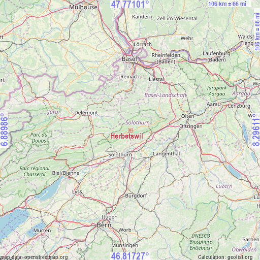
Herbetswil GPS coordinates[2]
47° 17' 46.644" North, 7° 35' 34.728" East
| Map corner | latitude | longitude |
|---|---|---|
| Upper-left | 47.77101°, | 6.88986° |
| Center: | 47.29629°, | 7.59298° |
| Lower-right: | 46.81727°, | 8.29611° |
| Map W x H: | 106×106 km | = 65.9×65.9mi |
| max Lat: | 47.76737° ⇑42.5% North |
| Herbetswil: | 47.29629° |
| min Lat: | ⇓57.5% South 45.83203° |
| min Long | Herbetswil | max Long |
| 5.97153° | 7.59298° | 10.44624° |
| W 28.1%⇐ | ⇒71.9% E |
Elevation
Elevation of Herbetswil is 525 m = 1722 ft, and this is 33.2 m = 109 ft below average elevation for this country.
| Max E: |
1845 m = 6053 ft | 39% |
| Avg. | 558.2 m = 1831 ft | |
| Herbetswil | 525 m = 1722 ft | |
Min E: |
197 m = 646 ft | 61% |
See also: Switzerland elevation on elevation.city.
Geographical zone
Herbetswil is located in North temperate zone (between Tropic of Cancer and the Arctic Circle). Distance of this North polar circle is 2142.3 km =1331.2 mi to North.| Distance of | km | miles | from Herbetswil |
|---|---|---|---|
| North Pole | 4748.2 | 2950.4 | to North |
| Arctic Circle | 2142.3 | 1331.2 | to North |
| Tropic Cancer | 2652.9 | 1648.4 | to South |
| Equator | 5258.9 | 3267.7 | to South |


Nearby cities:
15 places around Herbetswil: (largest is in red/bold)
• Aedermannsdorf
1.6 km =1 mi,  57°
57°
• Attiswil
5.7 km =3.5 mi,  164°
164°
• Balsthal
7.9 km =4.9 mi,  73°
73°
• Deitingen
9.2 km =5.7 mi,  167°
167°
• Laupersdorf
5 km =3.1 mi, 68°
• Luterbach
9.1 km =5.7 mi,  183°
183°
• Matzendorf
2.8 km =1.7 mi, 72°
• Mervelier
8.8 km =5.5 mi,  306°
306°
• Niederbipp
8.2 km =5.1 mi,  109°
109°
• Oberbipp
6.6 km =4.1 mi,  126°
126°
• Oensingen
9.3 km =5.8 mi,  95°
95°
• Riedholz
7.4 km =4.6 mi,  194°
194°
• Wangen an der Aare
8.4 km =5.2 mi,  147°
147°
• Welschenrohr
5.3 km =3.3 mi,  250°
250°
• Wiedlisbach
6.4 km =4 mi,  140°
140°
Sources, notices
• [Note1] Compared only with cities in Switzerland existing in our database
• [Src1] Map data: © OpenStreetMap contributors (CC-BY-SA)
• [Src2] Other city data from geonames.org with taken over terms of usage.
• [Src3] Geographical zone / Annual Mean Temperature by Robert A. Rohde @ Wikipedia
