Aedermannsdorf geodata
Aedermannsdorf (Solothurn) is a populated place; located in Switzerland in Europe/Zurich (GMT+2) time zone. With population of 548 people, there are 1748 cities with bigger population in this country. Compared to other cities in Switzerland, 58.4% of cities are located further ↓South; 71.3% of cities are located further →East and 60.3% of cities have lower elevation than Aedermannsdorf. Note1


Aedermannsdorf GPS coordinates[2]
47° 18' 13.464" North, 7° 36' 37.872" East
| Map corner | latitude | longitude |
|---|---|---|
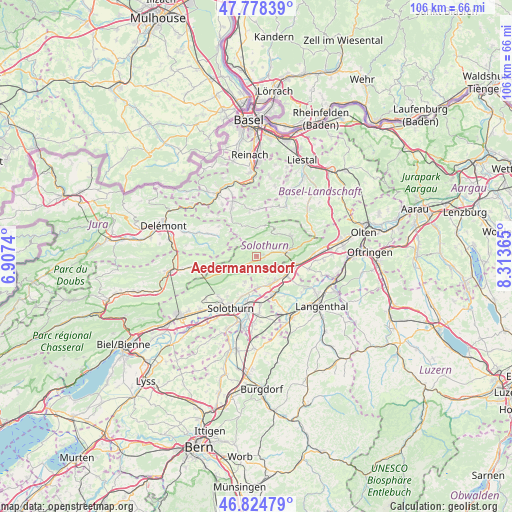
| Upper-left | 47.77839°, | 6.9074° |
| Center: | 47.30374°, | 7.61052° |
| Lower-right: | 46.82479°, | 8.31365° |
| Map W x H: | 106×106 km | = 65.9×65.9mi |
| max Lat: | 47.76737° ⇑41.6% North |
| Aedermannsdorf: | 47.30374° |
| min Lat: | ⇓58.4% South 45.83203° |
| min Long | Aedermannsdorf | max Long |
| 5.97153° | 7.61052° | 10.44624° |
| W 28.7%⇐ | ⇒71.3% E |
Elevation
Elevation of Aedermannsdorf is 520 m = 1706 ft, and this is 38.2 m = 125 ft below average elevation for this country.
| Max E: |
1845 m = 6053 ft | 39.7% |
| Avg. | 558.2 m = 1831 ft | |
| Aedermannsdorf | 520 m = 1706 ft | |
Min E: |
197 m = 646 ft | 60.3% |
See also: Switzerland elevation on elevation.city.
Geographical zone
Aedermannsdorf is located in North temperate zone (between Tropic of Cancer and the Arctic Circle). Distance of this North polar circle is 2141.5 km =1330.7 mi to North.| Distance of | km | miles | from Aedermannsdorf |
|---|---|---|---|
| North Pole | 4747.4 | 2949.9 | to North |
| Arctic Circle | 2141.5 | 1330.7 | to North |
| Tropic Cancer | 2653.8 | 1649 | to South |
| Equator | 5259.7 | 3268.2 | to South |


Nearby cities:
15 places around Aedermannsdorf: (largest is in red/bold)
• Attiswil
6.3 km =3.9 mi,  177°
177°
• Balsthal
6.4 km =4 mi,  77°
77°
• Erschwil
9.4 km =5.8 mi,  326°
326°
• Herbetswil
1.6 km =1 mi,  237°
237°
• Laupersdorf
3.5 km =2.2 mi,  73°
73°
• Matzendorf
1.3 km =0.8 mi,  90°
90°
• Mervelier
9.4 km =5.8 mi,  298°
298°
• Niederbipp
7.4 km =4.6 mi,  118°
118°
• Oberbipp
6.2 km =3.9 mi,  140°
140°
• Oensingen
8.2 km =5.1 mi,  102°
102°
• Riedholz
8.6 km =5.3 mi,  201°
201°
• Walliswil bei Niederbipp
9.6 km =6 mi, 141°
• Wangen an der Aare
8.6 km =5.3 mi,  158°
158°
• Welschenrohr
6.8 km =4.2 mi,  247°
247°
• Wiedlisbach
6.4 km =4 mi, 155°
Sources, notices
• [Note1] Compared only with cities in Switzerland existing in our database
• [Src1] Map data: © OpenStreetMap contributors (CC-BY-SA)
• [Src2] Other city data from geonames.org with taken over terms of usage.
• [Src3] Geographical zone / Annual Mean Temperature by Robert A. Rohde @ Wikipedia
