Riedholz geodata
Riedholz (Solothurn) is a populated place; located in Switzerland in Europe/Zurich (GMT+2) time zone. With population of 1,576 people, there are 989 cities with bigger population in this country. Compared to other cities in Switzerland, 50.1% of cities are located further ↑North; 73% of cities are located further →East and 52% of cities have higher elevation than Riedholz. Note1


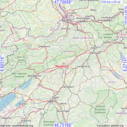
Riedholz GPS coordinates[2]
47° 13' 53.688" North, 7° 34' 5.844" East
| Map corner | latitude | longitude |
|---|---|---|
| Upper-left | 47.70688°, | 6.86516° |
| Center: | 47.23158°, | 7.56829° |
| Lower-right: | 46.75198°, | 8.27141° |
| Map W x H: | 106.2×106.2 km | = 66×66mi |
| max Lat: | 47.76737° ⇑50.1% North |
| Riedholz: | 47.23158° |
| min Lat: | ⇓49.9% South 45.83203° |
| min Long | Riedholz | max Long |
| 5.97153° | 7.56829° | 10.44624° |
| W 27%⇐ | ⇒73% E |
Elevation
Elevation of Riedholz is 474 m = 1555 ft, and this is 84.2 m = 276 ft below average elevation for this country.
| Max E: |
1845 m = 6053 ft | 52% |
| Avg. | 558.2 m = 1831 ft | |
| Riedholz | 474 m = 1555 ft | |
Min E: |
197 m = 646 ft | 48% |
See also: Switzerland elevation on elevation.city.
Geographical zone
Riedholz is located in North temperate zone (between Tropic of Cancer and the Arctic Circle). Distance of this North polar circle is 2149.5 km =1335.6 mi to North.| Distance of | km | miles | from Riedholz |
|---|---|---|---|
| North Pole | 4755.4 | 2954.9 | to North |
| Arctic Circle | 2149.5 | 1335.6 | to North |
| Tropic Cancer | 2645.7 | 1644 | to South |
| Equator | 5251.7 | 3263.3 | to South |


Nearby cities:
15 places around Riedholz: (largest is in red/bold)
• Attiswil
3.8 km =2.4 mi,  63°
63°
• Biberist
5.7 km =3.5 mi,  184°
184°
• Deitingen
4.2 km =2.6 mi,  115°
115°
• Derendingen
4 km =2.5 mi,  157°
157°
• Gerlafingen
6.8 km =4.2 mi, 177°
• Herbetswil
7.4 km =4.6 mi,  14°
14°
• Kriegstetten
6.7 km =4.2 mi, 160°
• Langendorf
4.3 km =2.7 mi,  251°
251°
• Luterbach
2.3 km =1.4 mi,  147°
147°
• Solothurn
3.5 km =2.2 mi,  221°
221°
• Subingen
5.3 km =3.3 mi,  133°
133°
• Wangen an der Aare
6.4 km =4 mi,  89°
89°
• Welschenrohr
6.3 km =3.9 mi,  329°
329°
• Wiedlisbach
6.3 km =3.9 mi,  68°
68°
• Zuchwil
3.3 km =2.1 mi, 182°
Sources, notices
• [Note1] Compared only with cities in Switzerland existing in our database
• [Src1] Map data: © OpenStreetMap contributors (CC-BY-SA)
• [Src2] Other city data from geonames.org with taken over terms of usage.
• [Src3] Geographical zone / Annual Mean Temperature by Robert A. Rohde @ Wikipedia
