Dörflingen geodata
Dörflingen (Schaffhausen) is a populated place; located in Switzerland in Europe/Zurich (GMT+2) time zone. With population of 890 people, there are 1427 cities with bigger population in this country. Compared to other cities in Switzerland, 99.6% of cities are located further ↓South; 76.4% of cities are located further ←West and 66.3% of cities have higher elevation than Dörflingen. Note1


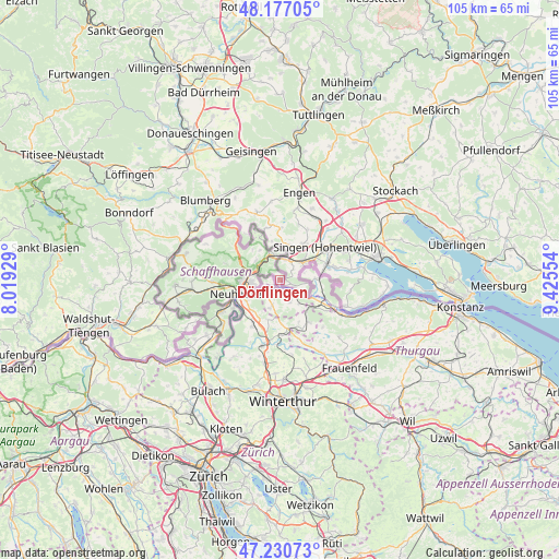
Dörflingen GPS coordinates[2]
47° 42' 21.744" North, 8° 43' 20.676" East
| Map corner | latitude | longitude |
|---|---|---|
| Upper-left | 48.17705°, | 8.01929° |
| Center: | 47.70604°, | 8.72241° |
| Lower-right: | 47.23073°, | 9.42554° |
| Map W x H: | 105.2×105.2 km | = 65.4×65.4mi |
| max Lat: | 47.76737° ⇑0.4% North |
| Dörflingen: | 47.70604° |
| min Lat: | ⇓99.6% South 45.83203° |
| min Long | Dörflingen | max Long |
| 5.97153° | 8.72241° | 10.44624° |
| W 76.4%⇐ | ⇒23.6% E |
Elevation
Elevation of Dörflingen is 444 m = 1457 ft, and this is 114.2 m = 375 ft below average elevation for this country.
| Max E: |
1845 m = 6053 ft | 66.3% |
| Avg. | 558.2 m = 1831 ft | |
| Dörflingen | 444 m = 1457 ft | |
Min E: |
197 m = 646 ft | 33.7% |
See also: Switzerland elevation on elevation.city.
Geographical zone
Dörflingen is located in North temperate zone (between Tropic of Cancer and the Arctic Circle). Distance of this North polar circle is 2096.8 km =1302.9 mi to North.| Distance of | km | miles | from Dörflingen |
|---|---|---|---|
| North Pole | 4702.6 | 2922.1 | to North |
| Arctic Circle | 2096.8 | 1302.9 | to North |
| Tropic Cancer | 2698.5 | 1676.8 | to South |
| Equator | 5304.4 | 3296 | to South |


Nearby cities:
15 places around Dörflingen: (largest is in red/bold)
• Benken
7.8 km =4.8 mi,  220°
220°
• Dachsen
9 km =5.6 mi,  239°
239°
• Diessenhofen
2.8 km =1.7 mi,  132°
132°
• Feuerthalen
6.1 km =3.8 mi,  253°
253°
• Flurlingen
7.3 km =4.5 mi, 250°
• Langwiesen
5.2 km =3.2 mi, 241°
• Lohn
6.8 km =4.2 mi,  323°
323°
• Neuhausen
8.4 km =5.2 mi, 254°
• Ramsen
6.5 km =4 mi,  88°
88°
• Schaffhausen
6.6 km =4.1 mi,  261°
261°
• Stetten
5.9 km =3.7 mi,  310°
310°
• Thayngen
4.7 km =2.9 mi,  346°
346°
• Trüllikon
8.2 km =5.1 mi,  197°
197°
• Uhwiesen
7.6 km =4.7 mi, 238°
• Unterstammheim
9 km =5.6 mi,  145°
145°
Sources, notices
• [Note1] Compared only with cities in Switzerland existing in our database
• [Src1] Map data: © OpenStreetMap contributors (CC-BY-SA)
• [Src2] Other city data from geonames.org with taken over terms of usage.
• [Src3] Geographical zone / Annual Mean Temperature by Robert A. Rohde @ Wikipedia
