Rothrist geodata
Rothrist (Aargau) is a populated place; located in Switzerland in Europe/Zurich (GMT+1) time zone. With population of 7,423 people, there are 220 cities with bigger population in this country. Compared to other cities in Switzerland, 58.7% of cities are located further ↓South; 62.8% of cities are located further →East and 85.1% of cities have higher elevation than Rothrist. Note1


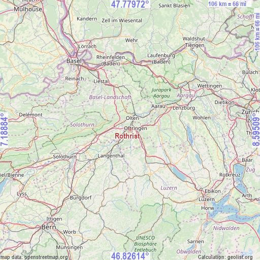
Rothrist GPS coordinates[2]
47° 18' 18.288" North, 7° 53' 31.056" East
| Map corner | latitude | longitude |
|---|---|---|
| Upper-left | 47.77972°, | 7.18884° |
| Center: | 47.30508°, | 7.89196° |
| Lower-right: | 46.82614°, | 8.59509° |
| Map W x H: | 106×106 km | = 65.9×65.9mi |
| max Lat: | 47.76737° ⇑41.3% North |
| Rothrist: | 47.30508° |
| min Lat: | ⇓58.7% South 45.83203° |
| min Long | Rothrist | max Long |
| 5.97153° | 7.89196° | 10.44624° |
| W 37.2%⇐ | ⇒62.8% E |
Elevation
Elevation of Rothrist is 410 m = 1345 ft, and this is 148.2 m = 486 ft below average elevation for this country.
| Max E: |
1845 m = 6053 ft | 85.1% |
| Avg. | 558.2 m = 1831 ft | |
| Rothrist | 410 m = 1345 ft | |
Min E: |
197 m = 646 ft | 14.9% |
See also: Switzerland elevation on elevation.city.
Geographical zone
Rothrist is located in North temperate zone (between Tropic of Cancer and the Arctic Circle). Distance of this North polar circle is 2141.3 km =1330.5 mi to North.| Distance of | km | miles | from Rothrist |
|---|---|---|---|
| North Pole | 4747.2 | 2949.8 | to North |
| Arctic Circle | 2141.3 | 1330.5 | to North |
| Tropic Cancer | 2653.9 | 1649.1 | to South |
| Equator | 5259.8 | 3268.3 | to South |


Nearby cities:
15 places around Rothrist: (largest is in red/bold)
• Aarburg
1.8 km =1.1 mi,  18°
18°
• Brittnau
6.5 km =4 mi,  140°
140°
• Fulenbach
5.9 km =3.7 mi,  230°
230°
• Gunzgen
4.7 km =2.9 mi,  281°
281°
• Hägendorf
5.1 km =3.2 mi,  311°
311°
• Murgenthal
5.5 km =3.4 mi, 226°
• Oftringen
2.7 km =1.7 mi,  68°
68°
• Olten
5.1 km =3.2 mi,  9°
9°
• Safenwil
7.1 km =4.4 mi, 74°
• Strengelbach
4 km =2.5 mi, 135°
• Trimbach
6.7 km =4.2 mi,  356°
356°
• Vordemwald
3.3 km =2.1 mi,  167°
167°
• Wangen
4.6 km =2.9 mi,  338°
338°
• Wikon
7.4 km =4.6 mi,  128°
128°
• Zofingen
4.5 km =2.8 mi,  115°
115°
Sources, notices
• [Note1] Compared only with cities in Switzerland existing in our database
• [Src1] Map data: © OpenStreetMap contributors (CC-BY-SA)
• [Src2] Other city data from geonames.org with taken over terms of usage.
• [Src3] Geographical zone / Annual Mean Temperature by Robert A. Rohde @ Wikipedia
