Balgach geodata
Balgach (Saint Gallen) is a populated place; located in Switzerland in Europe/Zurich (GMT+2) time zone. With population of 4,019 people, there are 439 cities with bigger population in this country. Compared to other cities in Switzerland, 74.8% of cities are located further ↓South; 98.4% of cities are located further ←West and 85.9% of cities have higher elevation than Balgach. Note1


Balgach GPS coordinates[2]
47° 24' 20.016" North, 9° 36' 25.272" East
| Map corner | latitude | longitude |
|---|---|---|
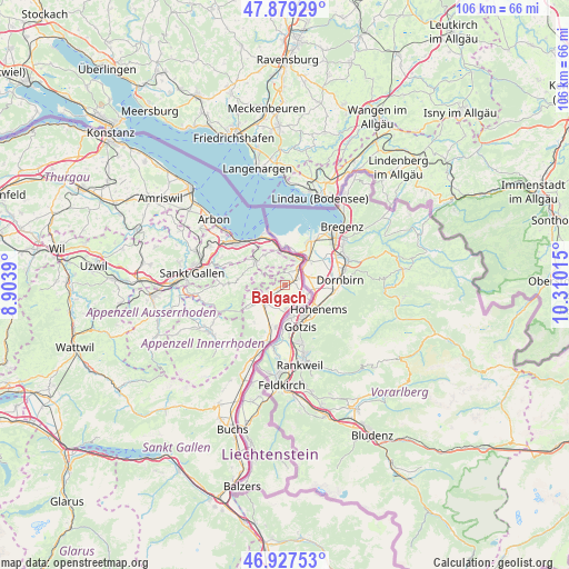
| Upper-left | 47.87929°, | 8.9039° |
| Center: | 47.40556°, | 9.60702° |
| Lower-right: | 46.92753°, | 10.31015° |
| Map W x H: | 105.8×105.8 km | = 65.7×65.7mi |
| max Lat: | 47.76737° ⇑25.2% North |
| Balgach: | 47.40556° |
| min Lat: | ⇓74.8% South 45.83203° |
| min Long | Balgach | max Long |
| 5.97153° | 9.60702° | 10.44624° |
| W 98.4%⇐ | ⇒1.6% E |
Elevation
Elevation of Balgach is 408 m = 1339 ft, and this is 150.2 m = 493 ft below average elevation for this country.
| Max E: |
1845 m = 6053 ft | 85.9% |
| Avg. | 558.2 m = 1831 ft | |
| Balgach | 408 m = 1339 ft | |
Min E: |
197 m = 646 ft | 14.1% |
See also: Switzerland elevation on elevation.city.
Geographical zone
Balgach is located in North temperate zone (between Tropic of Cancer and the Arctic Circle). Distance of this North polar circle is 2130.2 km =1323.6 mi to North.| Distance of | km | miles | from Balgach |
|---|---|---|---|
| North Pole | 4736.1 | 2942.9 | to North |
| Arctic Circle | 2130.2 | 1323.6 | to North |
| Tropic Cancer | 2665.1 | 1656 | to South |
| Equator | 5271 | 3275.2 | to South |


Nearby cities:
15 places around Balgach: (largest is in red/bold)
• Altstätten
5.5 km =3.4 mi,  235°
235°
• Au
3.5 km =2.2 mi,  36°
36°
• Diepoldsau
4.3 km =2.7 mi,  120°
120°
• Eggersriet
11.1 km =6.9 mi,  291°
291°
• Eichberg
8.9 km =5.5 mi,  219°
219°
• Heiden
6.9 km =4.3 mi,  306°
306°
• Oberegg
4.7 km =2.9 mi,  297°
297°
• Oberriet
9.9 km =6.2 mi,  197°
197°
• Rebstein
1.9 km =1.2 mi, 243°
• Rehetobel
9.6 km =6 mi,  283°
283°
• Rheineck
6.9 km =4.3 mi,  349°
349°
• Sankt Margrethen
5.7 km =3.5 mi,  23°
23°
• Thal
7.5 km =4.7 mi,  335°
335°
• Trogen
10.7 km =6.6 mi,  271°
271°
• Walzenhausen
4.8 km =3 mi,  358°
358°
Sources, notices
• [Note1] Compared only with cities in Switzerland existing in our database
• [Src1] Map data: © OpenStreetMap contributors (CC-BY-SA)
• [Src2] Other city data from geonames.org with taken over terms of usage.
• [Src3] Geographical zone / Annual Mean Temperature by Robert A. Rohde @ Wikipedia
