Auvernier geodata
Auvernier (Neuchâtel) is a populated place; located in Switzerland in Europe/Zurich (GMT+2) time zone. With population of 1,555 people, there are 1008 cities with bigger population in this country. Compared to other cities in Switzerland, 65.7% of cities are located further ↑North; 90% of cities are located further →East and 73.6% of cities have higher elevation than Auvernier. Note1


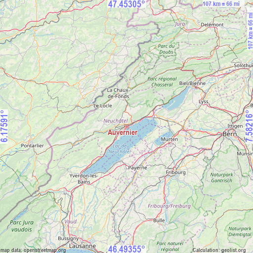
Auvernier GPS coordinates[2]
46° 58' 31.62" North, 6° 52' 44.508" East
| Map corner | latitude | longitude |
|---|---|---|
| Upper-left | 47.45305°, | 6.17591° |
| Center: | 46.97545°, | 6.87903° |
| Lower-right: | 46.49355°, | 7.58216° |
| Map W x H: | 106.7×106.7 km | = 66.3×66.3mi |
| max Lat: | 47.76737° ⇑65.7% North |
| Auvernier: | 46.97545° |
| min Lat: | ⇓34.3% South 45.83203° |
| min Long | Auvernier | max Long |
| 5.97153° | 6.87903° | 10.44624° |
| W 10%⇐ | ⇒90% E |
Elevation
Elevation of Auvernier is 434 m = 1424 ft, and this is 124.2 m = 407 ft below average elevation for this country.
| Max E: |
1845 m = 6053 ft | 73.6% |
| Avg. | 558.2 m = 1831 ft | |
| Auvernier | 434 m = 1424 ft | |
Min E: |
197 m = 646 ft | 26.4% |
See also: Switzerland elevation on elevation.city.
Geographical zone
Auvernier is located in North temperate zone (between Tropic of Cancer and the Arctic Circle). Distance of this North polar circle is 2178 km =1353.3 mi to North.| Distance of | km | miles | from Auvernier |
|---|---|---|---|
| North Pole | 4783.9 | 2972.6 | to North |
| Arctic Circle | 2178 | 1353.3 | to North |
| Tropic Cancer | 2617.3 | 1626.3 | to South |
| Equator | 5223.2 | 3245.5 | to South |


Nearby cities:
15 places around Auvernier: (largest is in red/bold)
• Bevaix
7.1 km =4.4 mi,  223°
223°
• Boudevilliers
5.8 km =3.6 mi,  7°
7°
• Boudry
4.2 km =2.6 mi,  227°
227°
• Cernier
9.4 km =5.8 mi, 9°
• Cortaillod
4.5 km =2.8 mi, 216°
• Fontainemelon
8.9 km =5.5 mi,  3°
3°
• Gletterens
10 km =6.2 mi,  153°
153°
• Grand-Savagnier
10.2 km =6.3 mi,  34°
34°
• La Sagne
9.4 km =5.8 mi,  326°
326°
• Les Geneveys-sur-Coffrane
4.9 km =3 mi, 334°
• Marin-Epagnier
9.9 km =6.2 mi,  67°
67°
• Neuchâtel
4.3 km =2.7 mi, 65°
• Peseux
1.5 km =0.9 mi, 30°
• Rochefort
5.4 km =3.4 mi,  272°
272°
• Saint-Blaise
9.4 km =5.8 mi,  61°
61°
Sources, notices
• [Note1] Compared only with cities in Switzerland existing in our database
• [Src1] Map data: © OpenStreetMap contributors (CC-BY-SA)
• [Src2] Other city data from geonames.org with taken over terms of usage.
• [Src3] Geographical zone / Annual Mean Temperature by Robert A. Rohde @ Wikipedia
