Appenzell geodata
Appenzell (Appenzell Innerrhoden) is a seat of a first-order administrative division; located in Switzerland in Europe/Zurich (GMT+2) time zone. With population of 5,649 people, there are 295 cities with bigger population in this country. Compared to other cities in Switzerland, 62.3% of cities are located further ↓South; 95.3% of cities are located further ←West and 88.1% of cities have lower elevation than Appenzell. Note1
Administrative division(s):
- Level 1: Appenzell Innerrhoden
- Level 2: Appenzell Inner Rhodes
- Level 3: Appenzell


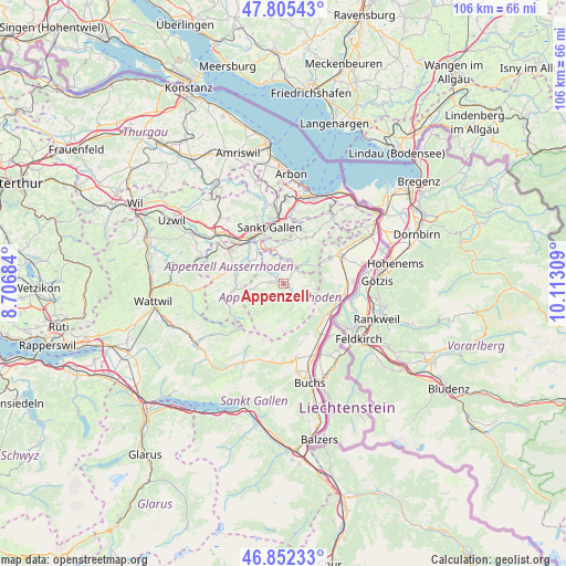
Appenzell GPS coordinates[2]
47° 19' 51.708" North, 9° 24' 35.856" East
| Map corner | latitude | longitude |
|---|---|---|
| Upper-left | 47.80543°, | 8.70684° |
| Center: | 47.33103°, | 9.40996° |
| Lower-right: | 46.85233°, | 10.11309° |
| Map W x H: | 106×106 km | = 65.9×65.9mi |
| max Lat: | 47.76737° ⇑37.7% North |
| Appenzell: | 47.33103° |
| min Lat: | ⇓62.3% South 45.83203° |
| min Long | Appenzell | max Long |
| 5.97153° | 9.40996° | 10.44624° |
| W 95.3%⇐ | ⇒4.7% E |
Elevation
Elevation of Appenzell is 783 m = 2569 ft, and this is 224.8 m = 738 ft above average elevation for this country.
| Max E: |
1845 m = 6053 ft | 11.9% |
| Appenzell | 783 m 2569 ft | |
| Avg. | 558.2 m = 1831 ft | |
Min E: |
197 m = 646 ft | 88.1% |
See also: Switzerland elevation on elevation.city.
Geographical zone
Appenzell is located in North temperate zone (between Tropic of Cancer and the Arctic Circle). Distance of this North polar circle is 2138.5 km =1328.8 mi to North.| Distance of | km | miles | from Appenzell |
|---|---|---|---|
| North Pole | 4744.3 | 2948 | to North |
| Arctic Circle | 2138.5 | 1328.8 | to North |
| Tropic Cancer | 2656.8 | 1650.9 | to South |
| Equator | 5262.7 | 3270.1 | to South |


Nearby cities:
15 places around Appenzell: (largest is in red/bold)
• Altstätten
11.6 km =7.2 mi,  63°
63°
• Bühler
4.9 km =3 mi,  13°
13°
• Eichberg
9.3 km =5.8 mi,  81°
81°
• Gais
4.7 km =2.9 mi,  44°
44°
• Gonten
4.8 km =3 mi,  264°
264°
• Haslen
5.3 km =3.3 mi,  323°
323°
• Hundwil
7.8 km =4.8 mi,  298°
298°
• Rüthi
10.5 km =6.5 mi,  112°
112°
• Sankt Gallen
10.7 km =6.6 mi,  345°
345°
• Sennwald
10.5 km =6.5 mi,  138°
138°
• Speicher
9.2 km =5.7 mi,  15°
15°
• Teufen
6.9 km =4.3 mi, 345°
• Trogen
9.5 km =5.9 mi,  25°
25°
• Urnäsch
10 km =6.2 mi, 260°
• Waldstatt
9.9 km =6.2 mi,  286°
286°
Sources, notices
• [Note1] Compared only with cities in Switzerland existing in our database
• [Src1] Map data: © OpenStreetMap contributors (CC-BY-SA)
• [Src2] Other city data from geonames.org with taken over terms of usage.
• [Src3] Geographical zone / Annual Mean Temperature by Robert A. Rohde @ Wikipedia
