Jonen geodata
Jonen (Aargau) is a populated place; located in Switzerland in Europe/Zurich (GMT+2) time zone. With population of 1,683 people, there are 950 cities with bigger population in this country. Compared to other cities in Switzerland, 57.7% of cities are located further ↓South; 50.8% of cities are located further →East and 85.9% of cities have higher elevation than Jonen. Note1


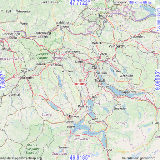
Jonen GPS coordinates[2]
47° 17' 51" North, 8° 23' 34.152" East
| Map corner | latitude | longitude |
|---|---|---|
| Upper-left | 47.7722°, | 7.6897° |
| Center: | 47.2975°, | 8.39282° |
| Lower-right: | 46.8185°, | 9.09595° |
| Map W x H: | 106×106 km | = 65.9×65.9mi |
| max Lat: | 47.76737° ⇑42.3% North |
| Jonen: | 47.2975° |
| min Lat: | ⇓57.7% South 45.83203° |
| min Long | Jonen | max Long |
| 5.97153° | 8.39282° | 10.44624° |
| W 49.2%⇐ | ⇒50.8% E |
Elevation
Elevation of Jonen is 408 m = 1339 ft, and this is 150.2 m = 493 ft below average elevation for this country.
| Max E: |
1845 m = 6053 ft | 85.9% |
| Avg. | 558.2 m = 1831 ft | |
| Jonen | 408 m = 1339 ft | |
Min E: |
197 m = 646 ft | 14.1% |
See also: Switzerland elevation on elevation.city.
Geographical zone
Jonen is located in North temperate zone (between Tropic of Cancer and the Arctic Circle). Distance of this North polar circle is 2142.2 km =1331.1 mi to North.| Distance of | km | miles | from Jonen |
|---|---|---|---|
| North Pole | 4748.1 | 2950.3 | to North |
| Arctic Circle | 2142.2 | 1331.1 | to North |
| Tropic Cancer | 2653.1 | 1648.6 | to South |
| Equator | 5259 | 3267.8 | to South |


Nearby cities:
15 places around Jonen: (largest is in red/bold)
• Affoltern / Goldiger Berg
4.5 km =2.8 mi,  118°
118°
• Aristau
2.5 km =1.6 mi,  241°
241°
• Besenbüren
4 km =2.5 mi,  297°
297°
• Hedingen
4.2 km =2.6 mi,  89°
89°
• Merenschwand
4.4 km =2.7 mi,  196°
196°
• Muri
4.8 km =3 mi, 237°
• Oberlunkhofen
1.7 km =1.1 mi,  358°
358°
• Obfelden
4.3 km =2.7 mi,  149°
149°
• Obfelden / Bickwil
3.9 km =2.4 mi,  142°
142°
• Obfelden / Oberlunnern
4.3 km =2.7 mi,  156°
156°
• Obfelden / Toussen
4.5 km =2.8 mi, 141°
• Ottenbach
1.9 km =1.2 mi, 152°
• Rottenschwil
3 km =1.9 mi,  307°
307°
• Unterlunkhofen
2.8 km =1.7 mi,  341°
341°
• Zwillikon
3.1 km =1.9 mi,  109°
109°
Sources, notices
• [Note1] Compared only with cities in Switzerland existing in our database
• [Src1] Map data: © OpenStreetMap contributors (CC-BY-SA)
• [Src2] Other city data from geonames.org with taken over terms of usage.
• [Src3] Geographical zone / Annual Mean Temperature by Robert A. Rohde @ Wikipedia
