Oberlunkhofen geodata
Oberlunkhofen (Aargau) is a seat of a third-order administrative division; located in Switzerland in Europe/Zurich (GMT+2) time zone. With population of 1,880 people, there are 880 cities with bigger population in this country. Compared to other cities in Switzerland, 59.6% of cities are located further ↓South; 50.8% of cities are located further →East and 63.8% of cities have higher elevation than Oberlunkhofen. Note1


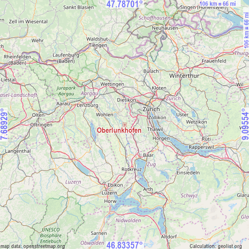
Oberlunkhofen GPS coordinates[2]
47° 18' 44.784" North, 8° 23' 32.712" East
| Map corner | latitude | longitude |
|---|---|---|
| Upper-left | 47.78701°, | 7.68929° |
| Center: | 47.31244°, | 8.39242° |
| Lower-right: | 46.83357°, | 9.09554° |
| Map W x H: | 106×106 km | = 65.9×65.9mi |
| max Lat: | 47.76737° ⇑40.4% North |
| Oberlunkhofen: | 47.31244° |
| min Lat: | ⇓59.6% South 45.83203° |
| min Long | Oberlunkhofen | max Long |
| 5.97153° | 8.39242° | 10.44624° |
| W 49.2%⇐ | ⇒50.8% E |
Elevation
Elevation of Oberlunkhofen is 448 m = 1470 ft, and this is 110.2 m = 362 ft below average elevation for this country.
| Max E: |
1845 m = 6053 ft | 63.8% |
| Avg. | 558.2 m = 1831 ft | |
| Oberlunkhofen | 448 m = 1470 ft | |
Min E: |
197 m = 646 ft | 36.2% |
See also: Switzerland elevation on elevation.city.
Geographical zone
Oberlunkhofen is located in North temperate zone (between Tropic of Cancer and the Arctic Circle). Distance of this North polar circle is 2140.5 km =1330 mi to North.| Distance of | km | miles | from Oberlunkhofen |
|---|---|---|---|
| North Pole | 4746.4 | 2949.3 | to North |
| Arctic Circle | 2140.5 | 1330 | to North |
| Tropic Cancer | 2654.7 | 1649.6 | to South |
| Equator | 5260.7 | 3268.8 | to South |


Nearby cities:
15 places around Oberlunkhofen: (largest is in red/bold)
• Aesch
4.5 km =2.8 mi,  53°
53°
• Affoltern / Goldiger Berg
5.5 km =3.4 mi,  133°
133°
• Affoltern / Unterdorf
5.7 km =3.5 mi, 125°
• Aristau
3.6 km =2.2 mi,  217°
217°
• Berikon
4.6 km =2.9 mi,  340°
340°
• Besenbüren
3.5 km =2.2 mi,  273°
273°
• Bonstetten
5.7 km =3.5 mi,  87°
87°
• Bünzen
5.2 km =3.2 mi, 266°
• Hedingen
4.5 km =2.8 mi,  110°
110°
• Jonen
1.7 km =1.1 mi,  178°
178°
• Obfelden / Bickwil
5.4 km =3.4 mi,  153°
153°
• Ottenbach
3.5 km =2.2 mi,  165°
165°
• Rottenschwil
2.3 km =1.4 mi, 273°
• Unterlunkhofen
1.3 km =0.8 mi,  318°
318°
• Zwillikon
4 km =2.5 mi, 132°
Sources, notices
• [Note1] Compared only with cities in Switzerland existing in our database
• [Src1] Map data: © OpenStreetMap contributors (CC-BY-SA)
• [Src2] Other city data from geonames.org with taken over terms of usage.
• [Src3] Geographical zone / Annual Mean Temperature by Robert A. Rohde @ Wikipedia
