Ebmatingen / Bachtobel geodata
Ebmatingen / Bachtobel (Zurich) is a section of populated place; located in Switzerland in Europe/Zurich (GMT+2) time zone. With population of 782 people, there are 1505 cities with bigger population in this country. Compared to other cities in Switzerland, 65% of cities are located further ↓South; 69.6% of cities are located further ←West and 73.3% of cities have lower elevation than Ebmatingen / Bachtobel. Note1
Current local time in Ebmatingen / Bachtobel:
07:36 AM, SaturdayDifference from your time zone: hours


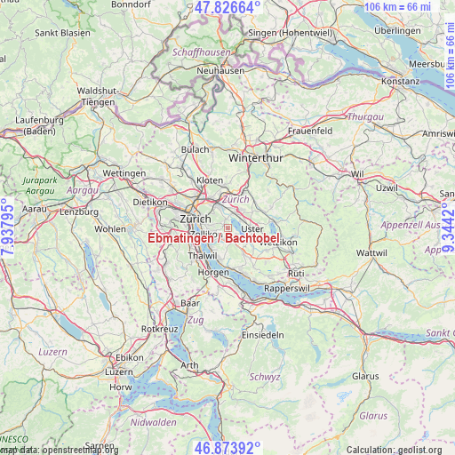
Ebmatingen / Bachtobel GPS coordinates[2]
47° 21' 8.748" North, 8° 38' 27.852" East
| Map corner | latitude | longitude |
|---|---|---|
| Upper-left | 47.82664°, | 7.93795° |
| Center: | 47.35243°, | 8.64107° |
| Lower-right: | 46.87392°, | 9.3442° |
| Map W x H: | 105.9×105.9 km | = 65.8×65.8mi |
| max Lat: | 47.76737° ⇑35% North |
| Ebmatingen / Bachtobel: | 47.35243° |
| min Lat: | ⇓65% South 45.83203° |
| min Long | Ebmatingen / Ba | max Long |
| 5.97153° | 8.64107° | 10.44624° |
| W 69.6%⇐ | ⇒30.4% E |
Elevation
Elevation of Ebmatingen / Bachtobel is 600 m = 1969 ft, and this is 41.8 m = 137 ft above average elevation for this country.
| Max E: |
1845 m = 6053 ft | 26.7% |
| Ebmatingen / Bachtobel | 600 m 1969 ft | |
| Avg. | 558.2 m = 1831 ft | |
Min E: |
197 m = 646 ft | 73.3% |
See also: Switzerland elevation on elevation.city.
Geographical zone
Ebmatingen / Bachtobel is located in North temperate zone (between Tropic of Cancer and the Arctic Circle). Distance of this North polar circle is 2136.1 km =1327.3 mi to North.| Distance of | km | miles | from Ebmatingen / Bachtobel |
|---|---|---|---|
| North Pole | 4742 | 2946.5 | to North |
| Arctic Circle | 2136.1 | 1327.3 | to North |
| Tropic Cancer | 2659.2 | 1652.3 | to South |
| Equator | 5265.1 | 3271.6 | to South |


Nearby cities:
15 places around Ebmatingen / Bachtobel: (largest is in red/bold)
• Aesch
2.7 km =1.7 mi,  158°
158°
• Benglen
1 km =0.6 mi,  341°
341°
• Binz
1.2 km =0.7 mi,  291°
291°
• Ebmatingen
0.3 km =0.2 mi,  193°
193°
• Ebmatingen / Lebern
0.4 km =0.2 mi,  167°
167°
• Fällanden
2.1 km =1.3 mi,  355°
355°
• Greifensee
3.4 km =2.1 mi,  61°
61°
• Pfaffhausen
1.9 km =1.2 mi,  316°
316°
• Scheuren
3.5 km =2.2 mi, 155°
• Schwerzenbach
3.5 km =2.2 mi,  20°
20°
• Schwerzenbach / Blatten
3.5 km =2.2 mi,  10°
10°
• Schwerzenbach / Widacher
3.5 km =2.2 mi, 20°
• Zollikerberg
3.1 km =1.9 mi,  254°
254°
• Zumikon
2.7 km =1.7 mi,  210°
210°
• Zumikon / Fröschgüllen
2.6 km =1.6 mi,  227°
227°
Sources, notices
• [Note1] Compared only with cities in Switzerland existing in our database
• [Src1] Map data: © OpenStreetMap contributors (CC-BY-SA)
• [Src2] Other city data from geonames.org with taken over terms of usage.
• [Src3] Geographical zone / Annual Mean Temperature by Robert A. Rohde @ Wikipedia
