Ebmatingen / Lebern geodata
Ebmatingen / Lebern (Zurich) is a section of populated place; located in Switzerland in Europe/Zurich (GMT+2) time zone. With population of 571 people, there are 1725 cities with bigger population in this country. Compared to other cities in Switzerland, 64.4% of cities are located further ↓South; 69.6% of cities are located further ←West and 77.5% of cities have lower elevation than Ebmatingen / Lebern. Note1


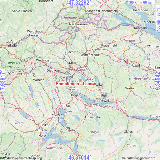
Ebmatingen / Lebern GPS coordinates[2]
47° 20' 55.248" North, 8° 38' 32.244" East
| Map corner | latitude | longitude |
|---|---|---|
| Upper-left | 47.82292°, | 7.93917° |
| Center: | 47.34868°, | 8.64229° |
| Lower-right: | 46.87014°, | 9.34542° |
| Map W x H: | 105.9×105.9 km | = 65.8×65.8mi |
| max Lat: | 47.76737° ⇑35.6% North |
| Ebmatingen / Lebern: | 47.34868° |
| min Lat: | ⇓64.4% South 45.83203° |
| min Long | Ebmatingen / Le | max Long |
| 5.97153° | 8.64229° | 10.44624° |
| W 69.6%⇐ | ⇒30.4% E |
Elevation
Elevation of Ebmatingen / Lebern is 638 m = 2093 ft, and this is 79.8 m = 262 ft above average elevation for this country.
| Max E: |
1845 m = 6053 ft | 22.5% |
| Ebmatingen / Lebern | 638 m 2093 ft | |
| Avg. | 558.2 m = 1831 ft | |
Min E: |
197 m = 646 ft | 77.5% |
See also: Switzerland elevation on elevation.city.
Geographical zone
Ebmatingen / Lebern is located in North temperate zone (between Tropic of Cancer and the Arctic Circle). Distance of this North polar circle is 2136.5 km =1327.6 mi to North.| Distance of | km | miles | from Ebmatingen / Lebern |
|---|---|---|---|
| North Pole | 4742.4 | 2946.8 | to North |
| Arctic Circle | 2136.5 | 1327.6 | to North |
| Tropic Cancer | 2658.8 | 1652.1 | to South |
| Equator | 5264.7 | 3271.3 | to South |


Nearby cities:
15 places around Ebmatingen / Lebern: (largest is in red/bold)
• Aesch
2.3 km =1.4 mi,  157°
157°
• Benglen
1.4 km =0.9 mi,  343°
343°
• Binz
1.5 km =0.9 mi,  305°
305°
• Ebmatingen
0.2 km =0.1 mi, 309°
• Ebmatingen / Bachtobel
0.4 km =0.2 mi,  347°
347°
• Fällanden
2.6 km =1.6 mi, 353°
• Greifensee
3.6 km =2.2 mi,  54°
54°
• Greifensee / Müllerwis / Seilerwis
3.8 km =2.4 mi, 50°
• Greifensee / Ocht
3.8 km =2.4 mi,  43°
43°
• Pfaffhausen
2.3 km =1.4 mi,  322°
322°
• Scheuren
3 km =1.9 mi,  153°
153°
• Schwerzenbach / Widacher
3.8 km =2.4 mi,  17°
17°
• Zollikerberg
3.1 km =1.9 mi,  262°
262°
• Zumikon
2.4 km =1.5 mi,  217°
217°
• Zumikon / Fröschgüllen
2.4 km =1.5 mi,  236°
236°
Sources, notices
• [Note1] Compared only with cities in Switzerland existing in our database
• [Src1] Map data: © OpenStreetMap contributors (CC-BY-SA)
• [Src2] Other city data from geonames.org with taken over terms of usage.
• [Src3] Geographical zone / Annual Mean Temperature by Robert A. Rohde @ Wikipedia
