Sakassou geodata
Sakassou (Vallée du Bandama) is a seat of a third-order administrative division; located in Ivory Coast in Africa/Abidjan (GMT+0) time zone. With population of 15,068 people, there are 55 cities with bigger population in this country. Compared to other cities in Ivory Coast, 63.2% of cities are located further ↓South; 51.3% of cities are located further →East and 54.7% of cities have lower elevation than Sakassou. Note1


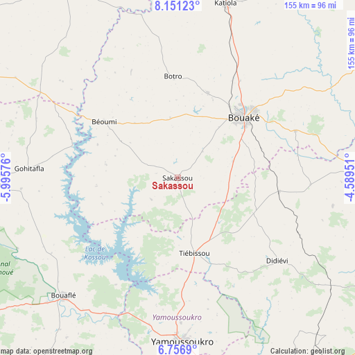
Sakassou GPS coordinates[2]
7° 27' 16.632" North, 5° 17' 33.468" West
| Map corner | latitude | longitude |
|---|---|---|
| Upper-left | 8.15123°, | -5.99576° |
| Center: | 7.45462°, | -5.29263° |
| Lower-right: | 6.7569°, | -4.58951° |
| Map W x H: | 155×155 km | = 96.3×96.3mi |
| max Lat: | 10.48115° ⇑36.8% North |
| Sakassou: | 7.45462° |
| min Lat: | ⇓63.2% South 4.42295° |
| min Long | Sakassou | max Long |
| -8.42592° | -5.29263° | -2.80003° |
| W 48.7%⇐ | ⇒51.3% E |
Elevation
Elevation of Sakassou is 231 m = 758 ft, and this is 6.7 m = 22 ft above average elevation for this country.
| Max E: |
556 m = 1824 ft | 45.3% |
| Sakassou | 231 m 758 ft | |
| Avg. | 224.3 m = 736 ft | |
Min E: |
7 m = 23 ft | 54.7% |
See also: Ivory Coast elevation on elevation.city.
Geographical zone
Sakassou is located in North Torrid zone (between Equator and Tropic of Cancer). Distance of Equator is 828.9 km =515.1 mi to South.| Distance of | km | miles | from Sakassou |
|---|---|---|---|
| North Pole | 9178.2 | 5703.1 | to North |
| Arctic Circle | 6572.3 | 4083.8 | to North |
| Tropic Cancer | 1777 | 1104.2 | to North |
| Equator | 828.9 | 515.1 | to South |


Nearby cities:
15 places around Sakassou: (largest is in red/bold)
• Attiégouakro
78.2 km =48.6 mi,  165°
165°
• Bocanda
97.7 km =60.7 mi,  116°
116°
• Botro
44.3 km =27.5 mi,  357°
357°
• Bouaflé
71.7 km =44.6 mi,  223°
223°
• Bouaké
39.3 km =24.4 mi,  47°
47°
• Béoumi
40 km =24.9 mi,  307°
307°
• Didiévi
56.6 km =35.2 mi,  129°
129°
• Katiola
78.8 km =49 mi,  15°
15°
• Kouassi-Kouassikro
69 km =42.9 mi,  100°
100°
• Kounahiri
70.5 km =43.8 mi,  302°
302°
• M’Bahiakro
105 km =65.2 mi,  89°
89°
• Tiébissou
33.8 km =21 mi, 167°
• Toumodi
104.2 km =64.7 mi,  163°
163°
• Yamoussoukro
70.5 km =43.8 mi,  178°
178°
• Zuénoula
83.6 km =51.9 mi,  268°
268°
Sources, notices
• [Note1] Compared only with cities in Ivory Coast existing in our database
• [Src1] Map data: © OpenStreetMap contributors (CC-BY-SA)
• [Src2] Other city data from geonames.org with taken over terms of usage.
• [Src3] Geographical zone / Annual Mean Temperature by Robert A. Rohde @ Wikipedia
