Bouaflé geodata
Bouaflé (Sassandra-Marahoué) is a seat of a second-order administrative division; located in Ivory Coast in Africa/Abidjan (GMT+0) time zone. With population of 60,962 people, there are 18 cities with bigger population in this country. Compared to other cities in Ivory Coast, 51.3% of cities are located further ↓South; 59% of cities are located further →East and 55.6% of cities have higher elevation than Bouaflé. Note1


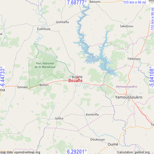
Bouaflé GPS coordinates[2]
6° 59' 25.476" North, 5° 44' 39.12" West
| Map corner | latitude | longitude |
|---|---|---|
| Upper-left | 7.68777°, | -6.44733° |
| Center: | 6.99041°, | -5.7442° |
| Lower-right: | 6.29201°, | -5.04108° |
| Map W x H: | 155.2×155.2 km | = 96.4×96.4mi |
| max Lat: | 10.48115° ⇑48.7% North |
| Bouaflé: | 6.99041° |
| min Lat: | ⇓51.3% South 4.42295° |
| min Long | Bouaflé | max Long |
| -8.42592° | -5.7442° | -2.80003° |
| W 41%⇐ | ⇒59% E |
Elevation
Elevation of Bouaflé is 208 m = 682 ft, and this is 16.3 m = 53 ft below average elevation for this country.
| Max E: |
556 m = 1824 ft | 55.6% |
| Avg. | 224.3 m = 736 ft | |
| Bouaflé | 208 m = 682 ft | |
Min E: |
7 m = 23 ft | 44.4% |
See also: Bouaflé elevation on elevation.city.
Geographical zone
Bouaflé is located in North Torrid zone (between Equator and Tropic of Cancer). Distance of Equator is 777.3 km =483 mi to South.| Distance of | km | miles | from Bouaflé |
|---|---|---|---|
| North Pole | 9229.8 | 5735.1 | to North |
| Arctic Circle | 6623.9 | 4115.9 | to North |
| Tropic Cancer | 1828.7 | 1136.3 | to North |
| Equator | 777.3 | 483 | to South |


Nearby cities:
15 places around Bouaflé: (largest is in red/bold)
• Attiégouakro
73.6 km =45.7 mi,  109°
109°
• Béoumi
78.1 km =48.5 mi,  13°
13°
• Daloa
78.9 km =49 mi,  260°
260°
• Didiévi
94.6 km =58.8 mi,  80°
80°
• Djékanou
89.4 km =55.6 mi,  129°
129°
• Guibéroua
96 km =59.7 mi,  209°
209°
• Kounahiri
89.6 km =55.7 mi,  353°
353°
• Oumé
76.6 km =47.6 mi,  151°
151°
• Sakassou
71.7 km =44.6 mi,  43°
43°
• Sinfra
45 km =28 mi,  204°
204°
• Tiébissou
60.3 km =37.5 mi,  72°
72°
• Toumodi
93.5 km =58.1 mi,  120°
120°
• Vavoua
91.9 km =57.1 mi,  298°
298°
• Yamoussoukro
54.9 km =34.1 mi, 110°
• Zuénoula
59.4 km =36.9 mi,  325°
325°
Sources, notices
• [Note1] Compared only with cities in Ivory Coast existing in our database
• [Src1] Map data: © OpenStreetMap contributors (CC-BY-SA)
• [Src2] Other city data from geonames.org with taken over terms of usage.
• [Src3] Geographical zone / Annual Mean Temperature by Robert A. Rohde @ Wikipedia
