Guibéroua geodata
Guibéroua (Gôh-Djiboua) is a populated place; located in Ivory Coast in Africa/Abidjan (GMT+0) time zone. With population of 13,186 people, there are 59 cities with bigger population in this country. Compared to other cities in Ivory Coast, 69.2% of cities are located further ↑North; 66.7% of cities are located further →East and 53.8% of cities have lower elevation than Guibéroua. Note1


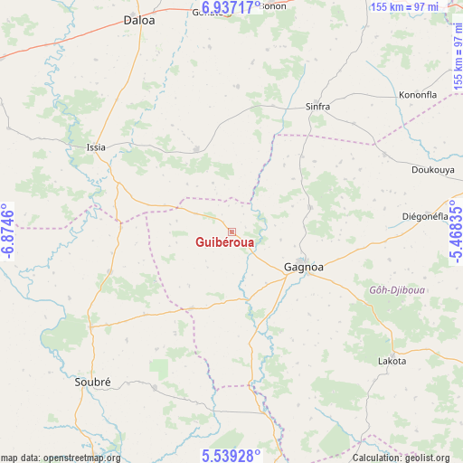
Guibéroua GPS coordinates[2]
6° 14' 19.284" North, 6° 10' 17.292" West
| Map corner | latitude | longitude |
|---|---|---|
| Upper-left | 6.93717°, | -6.8746° |
| Center: | 6.23869°, | -6.17147° |
| Lower-right: | 5.53928°, | -5.46835° |
| Map W x H: | 155.4×155.4 km | = 96.6×96.6mi |
| max Lat: | 10.48115° ⇑69.2% North |
| Guibéroua: | 6.23869° |
| min Lat: | ⇓30.8% South 4.42295° |
| min Long | Guibéroua | max Long |
| -8.42592° | -6.17147° | -2.80003° |
| W 33.3%⇐ | ⇒66.7% E |
Elevation
Elevation of Guibéroua is 230 m = 755 ft, and this is 5.7 m = 19 ft above average elevation for this country.
| Max E: |
556 m = 1824 ft | 46.2% |
| Guibéroua | 230 m 755 ft | |
| Avg. | 224.3 m = 736 ft | |
Min E: |
7 m = 23 ft | 53.8% |
See also: Ivory Coast elevation on elevation.city.
Geographical zone
Guibéroua is located in North Torrid zone (between Equator and Tropic of Cancer). Distance of Equator is 693.7 km =431 mi to South.| Distance of | km | miles | from Guibéroua |
|---|---|---|---|
| North Pole | 9313.4 | 5787.1 | to North |
| Arctic Circle | 6707.5 | 4167.8 | to North |
| Tropic Cancer | 1912.2 | 1188.2 | to North |
| Equator | 693.7 | 431 | to South |


Nearby cities:
15 places around Guibéroua: (largest is in red/bold)
• Bouaflé
96 km =59.7 mi,  29°
29°
• Buyo
91.3 km =56.7 mi,  272°
272°
• Daloa
77.4 km =48.1 mi,  336°
336°
• Divo
100.5 km =62.4 mi,  116°
116°
• Djékanou
119.8 km =74.4 mi,  76°
76°
• Gagnoa
27.1 km =16.8 mi, 115°
• Guéyo
62.2 km =38.6 mi,  169°
169°
• Issia
53.7 km =33.4 mi,  301°
301°
• Lakota
69.4 km =43.1 mi,  128°
128°
• Oumé
84.8 km =52.7 mi, 79°
• Sinfra
51.3 km =31.9 mi, 34°
• Soubré
68.9 km =42.8 mi,  222°
222°
• Taabo
117.5 km =73 mi,  92°
92°
• Yamoussoukro
118.1 km =73.4 mi,  56°
56°
• Zoukougbeu
96.1 km =59.7 mi,  307°
307°
Sources, notices
• [Note1] Compared only with cities in Ivory Coast existing in our database
• [Src1] Map data: © OpenStreetMap contributors (CC-BY-SA)
• [Src2] Other city data from geonames.org with taken over terms of usage.
• [Src3] Geographical zone / Annual Mean Temperature by Robert A. Rohde @ Wikipedia
