Vavoua geodata
Vavoua (Sassandra-Marahoué) is a seat of a third-order administrative division; located in Ivory Coast in Africa/Abidjan (GMT+0) time zone. With population of 31,250 people, there are 43 cities with bigger population in this country. Compared to other cities in Ivory Coast, 59.8% of cities are located further ↓South; 71.8% of cities are located further →East and 67.5% of cities have lower elevation than Vavoua. Note1


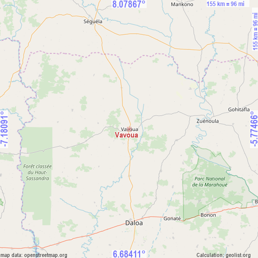
Vavoua GPS coordinates[2]
7° 22' 54.984" North, 6° 28' 40.008" West
| Map corner | latitude | longitude |
|---|---|---|
| Upper-left | 8.07867°, | -7.18091° |
| Center: | 7.38194°, | -6.47778° |
| Lower-right: | 6.68411°, | -5.77466° |
| Map W x H: | 155.1×155.1 km | = 96.4×96.4mi |
| max Lat: | 10.48115° ⇑40.2% North |
| Vavoua: | 7.38194° |
| min Lat: | ⇓59.8% South 4.42295° |
| min Long | Vavoua | max Long |
| -8.42592° | -6.47778° | -2.80003° |
| W 28.2%⇐ | ⇒71.8% E |
Elevation
Elevation of Vavoua is 276 m = 906 ft, and this is 51.7 m = 170 ft above average elevation for this country.
| Max E: |
556 m = 1824 ft | 32.5% |
| Vavoua | 276 m 906 ft | |
| Avg. | 224.3 m = 736 ft | |
Min E: |
7 m = 23 ft | 67.5% |
See also: Ivory Coast elevation on elevation.city.
Geographical zone
Vavoua is located in North Torrid zone (between Equator and Tropic of Cancer). Distance of Equator is 820.8 km =510 mi to South.| Distance of | km | miles | from Vavoua |
|---|---|---|---|
| North Pole | 9186.3 | 5708.1 | to North |
| Arctic Circle | 6580.4 | 4088.9 | to North |
| Tropic Cancer | 1785.1 | 1109.2 | to North |
| Equator | 820.8 | 510 | to South |


Nearby cities:
15 places around Vavoua: (largest is in red/bold)
• Bangolo
118.6 km =73.7 mi,  249°
249°
• Bouaflé
91.9 km =57.1 mi,  118°
118°
• Béoumi
104.1 km =64.7 mi,  71°
71°
• Daloa
56.2 km =34.9 mi,  176°
176°
• Duekoué
119.6 km =74.3 mi,  233°
233°
• Facobly
99.1 km =61.6 mi,  270°
270°
• Issia
99.6 km =61.9 mi,  186°
186°
• Kouibly
84.7 km =52.6 mi,  260°
260°
• Kounahiri
84.2 km =52.3 mi,  57°
57°
• Man
118.7 km =73.8 mi, 271°
• Mankono
81.7 km =50.8 mi,  22°
22°
• Sinfra
105.2 km =65.4 mi,  143°
143°
• Séguéla
67.9 km =42.2 mi,  341°
341°
• Zoukougbeu
81 km =50.3 mi,  211°
211°
• Zuénoula
47.4 km =29.5 mi,  83°
83°
Sources, notices
• [Note1] Compared only with cities in Ivory Coast existing in our database
• [Src1] Map data: © OpenStreetMap contributors (CC-BY-SA)
• [Src2] Other city data from geonames.org with taken over terms of usage.
• [Src3] Geographical zone / Annual Mean Temperature by Robert A. Rohde @ Wikipedia
