San Felipe geodata
San Felipe (Valparaíso) is a seat of a second-order administrative division; located in Chile in America/Santiago (GMT-4) time zone. With population of 59,294 people, there are 36 cities with bigger population in this country. Compared to other cities in Chile, 83.4% of cities are located further ↓South; 80% of cities are located further ←West and 93.8% of cities have lower elevation than San Felipe. Note1
Administrative division(s):
- Level 1: Valparaíso
- Level 2: Provincia de San Felipe de Aconcagua
- Level 3: San Felipe


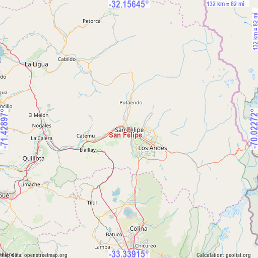
San Felipe GPS coordinates[2]
32° 44' 59.136" South, 70° 43' 33.024" West
| Map corner | latitude | longitude |
|---|---|---|
| Upper-left | -32.15645°, | -71.42897° |
| Center: | -32.74976°, | -70.72584° |
| Lower-right: | -33.33915°, | -70.02272° |
| Map W x H: | 131.5×131.5 km | = 81.7×81.7mi |
| max Lat: | -18.19821° ⇑16.6% North |
| San Felipe: | -32.74976° |
| min Lat: | ⇓83.4% South -54.93355° |
| min Long | San Felipe | max Long |
| -109.42438° | -70.72584° | -67.60963° |
| W 80%⇐ | ⇒20% E |
Elevation
Elevation of San Felipe is 654 m = 2146 ft, and this is 381 m = 1250 ft above average elevation for this country.
| Max E: |
3544 m = 11627 ft | 6.2% |
| San Felipe | 654 m 2146 ft | |
| Avg. | 273 m = 896 ft | |
Min E: |
1 m = 3 ft | 93.8% |
See also: San Felipe elevation on elevation.city.
Geographical zone
San Felipe is located in South temperate zone (between Tropic of Capricorn and the Antarctic Circle). Distance of this Southern Tropic circle is 1035.5 km =643.4 mi to North.| Distance of | km | miles | from San Felipe |
|---|---|---|---|
| Equator | 3641.4 | 2262.7 | to North |
| Tropic Capricorn | 1035.5 | 643.4 | to North |
| Antarctic Circle | 3759.7 | 2336.2 | to South |
| South Pole | 6365.6 | 3955.4 | to South |


Nearby cities:
15 places around San Felipe: (largest is in red/bold)
• Chicureo Abajo
59.8 km =37.2 mi,  173°
173°
• Colina
50.8 km =31.6 mi, 174°
• Hacienda La Calera
46 km =28.6 mi,  265°
265°
• La Ligua
57.7 km =35.9 mi,  304°
304°
• Lampa
61.3 km =38.1 mi,  193°
193°
• Limache
58.6 km =36.4 mi,  239°
239°
• Llaillay
23.8 km =14.8 mi, 244°
• Lo Prado
77.2 km =48 mi,  179°
179°
• Los Andes
15.1 km =9.4 mi,  128°
128°
• Providencia
76.6 km =47.6 mi, 171°
• Quillota
51.1 km =31.8 mi,  253°
253°
• Quilpué
74.6 km =46.4 mi, 243°
• Santiago
79 km =49.1 mi, 174°
• Villa Alemana
68.6 km =42.6 mi, 241°
• Villa Presidente Frei, Ñuñoa, Santiago, Chile
80.2 km =49.8 mi, 170°
Sources, notices
• [Note1] Compared only with cities in Chile existing in our database
• [Src1] Map data: © OpenStreetMap contributors (CC-BY-SA)
• [Src2] Other city data from geonames.org with taken over terms of usage.
• [Src3] Geographical zone / Annual Mean Temperature by Robert A. Rohde @ Wikipedia
