San Antonio geodata
San Antonio (Valparaíso) is a seat of a second-order administrative division; located in Chile in America/Santiago (GMT-4) time zone. With population of 85,651 people, there are 29 cities with bigger population in this country. Compared to other cities in Chile, 69% of cities are located further ↓South; 53.8% of cities are located further ←West and 71.7% of cities have higher elevation than San Antonio. Note1


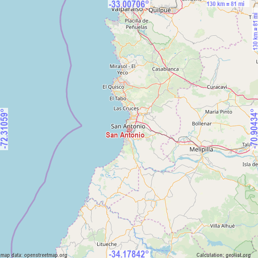
San Antonio GPS coordinates[2]
33° 35' 41.028" South, 71° 36' 26.856" West
| Map corner | latitude | longitude |
|---|---|---|
| Upper-left | -33.00706°, | -72.31059° |
| Center: | -33.59473°, | -71.60746° |
| Lower-right: | -34.17842°, | -70.90434° |
| Map W x H: | 130.2×130.2 km | = 80.9×80.9mi |
| max Lat: | -18.19821° ⇑31% North |
| San Antonio: | -33.59473° |
| min Lat: | ⇓69% South -54.93355° |
| min Long | San Antonio | max Long |
| -109.42438° | -71.60746° | -67.60963° |
| W 53.8%⇐ | ⇒46.2% E |
Elevation
Elevation of San Antonio is 39 m = 128 ft, and this is 234 m = 768 ft below average elevation for this country.
| Max E: |
3544 m = 11627 ft | 71.7% |
| Avg. | 273 m = 896 ft | |
| San Antonio | 39 m = 128 ft | |
Min E: |
1 m = 3 ft | 28.3% |
See also: San Antonio elevation on elevation.city.
Geographical zone
San Antonio is located in South temperate zone (between Tropic of Capricorn and the Antarctic Circle). Distance of this Southern Tropic circle is 1129.5 km =701.8 mi to North.| Distance of | km | miles | from San Antonio |
|---|---|---|---|
| Equator | 3735.4 | 2321.1 | to North |
| Tropic Capricorn | 1129.5 | 701.8 | to North |
| Antarctic Circle | 3665.8 | 2277.8 | to South |
| South Pole | 6271.7 | 3897.1 | to South |


Nearby cities:
15 places around San Antonio: (largest is in red/bold)
• Buin
81.5 km =50.6 mi,  100°
100°
• Cartagena
4.5 km =2.8 mi,  359°
359°
• El Monte
58.4 km =36.3 mi, 99°
• El Tabo
17 km =10.6 mi,  341°
341°
• Lampa
76.1 km =47.3 mi,  63°
63°
• Limache
71.7 km =44.6 mi,  26°
26°
• Lo Prado
83.4 km =51.8 mi,  78°
78°
• Melipilla
37.8 km =23.5 mi,  106°
106°
• Paine
83.6 km =51.9 mi, 106°
• Peñaflor
67.7 km =42.1 mi,  91°
91°
• Quilpué
62.7 km =39 mi,  14°
14°
• Talagante
63.4 km =39.4 mi, 96°
• Valparaíso
62.2 km =38.6 mi, 358°
• Villa Alemana
65.2 km =40.5 mi,  19°
19°
• Viña del Mar
63.6 km =39.5 mi,  4°
4°
Sources, notices
• [Note1] Compared only with cities in Chile existing in our database
• [Src1] Map data: © OpenStreetMap contributors (CC-BY-SA)
• [Src2] Other city data from geonames.org with taken over terms of usage.
• [Src3] Geographical zone / Annual Mean Temperature by Robert A. Rohde @ Wikipedia
