Cartagena geodata
Cartagena (Valparaíso) is a populated place; located in Chile in America/Santiago (GMT-4) time zone. With population of 16,875 people, there are 89 cities with bigger population in this country. Compared to other cities in Chile, 71% of cities are located further ↓South; 53.1% of cities are located further ←West and 62.1% of cities have higher elevation than Cartagena. Note1


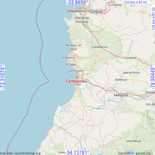
Cartagena GPS coordinates[2]
33° 33' 13.824" South, 71° 36' 27.396" West
| Map corner | latitude | longitude |
|---|---|---|
| Upper-left | -32.9659°, | -72.31074° |
| Center: | -33.55384°, | -71.60761° |
| Lower-right: | -34.13781°, | -70.90449° |
| Map W x H: | 130.3×130.3 km | = 81×81mi |
| max Lat: | -18.19821° ⇑29% North |
| Cartagena: | -33.55384° |
| min Lat: | ⇓71% South -54.93355° |
| min Long | Cartagena | max Long |
| -109.42438° | -71.60761° | -67.60963° |
| W 53.1%⇐ | ⇒46.9% E |
Elevation
Elevation of Cartagena is 82 m = 269 ft, and this is 191 m = 627 ft below average elevation for this country.
| Max E: |
3544 m = 11627 ft | 62.1% |
| Avg. | 273 m = 896 ft | |
| Cartagena | 82 m = 269 ft | |
Min E: |
1 m = 3 ft | 37.9% |
See also: Chile elevation on elevation.city.
Geographical zone
Cartagena is located in South temperate zone (between Tropic of Capricorn and the Antarctic Circle). Distance of this Southern Tropic circle is 1124.9 km =699 mi to North.| Distance of | km | miles | from Cartagena |
|---|---|---|---|
| Equator | 3730.8 | 2318.2 | to North |
| Tropic Capricorn | 1124.9 | 699 | to North |
| Antarctic Circle | 3670.3 | 2280.6 | to South |
| South Pole | 6276.2 | 3899.8 | to South |


Nearby cities:
15 places around Cartagena: (largest is in red/bold)
• Buin
82.5 km =51.3 mi,  103°
103°
• El Monte
59.3 km =36.8 mi, 103°
• El Tabo
12.8 km =8 mi,  334°
334°
• Lampa
74.2 km =46.1 mi,  66°
66°
• Limache
67.6 km =42 mi,  27°
27°
• Lo Prado
82.7 km =51.4 mi,  81°
81°
• Melipilla
39.3 km =24.4 mi,  112°
112°
• Peñaflor
68 km =42.3 mi,  94°
94°
• Quillota
81.7 km =50.8 mi,  24°
24°
• Quilpué
58.4 km =36.3 mi, 15°
• San Antonio
4.5 km =2.8 mi,  179°
179°
• Talagante
64.2 km =39.9 mi, 100°
• Valparaíso
57.6 km =35.8 mi,  357°
357°
• Villa Alemana
60.9 km =37.8 mi, 20°
• Viña del Mar
59.1 km =36.7 mi,  5°
5°
Sources, notices
• [Note1] Compared only with cities in Chile existing in our database
• [Src1] Map data: © OpenStreetMap contributors (CC-BY-SA)
• [Src2] Other city data from geonames.org with taken over terms of usage.
• [Src3] Geographical zone / Annual Mean Temperature by Robert A. Rohde @ Wikipedia
