Diego de Almagro geodata
Diego de Almagro (Atacama) is a populated place; located in Chile in America/Santiago (GMT-4) time zone. With population of 18,137 people, there are 85 cities with bigger population in this country. Compared to other cities in Chile, 92.4% of cities are located further ↓South; 95.2% of cities are located further ←West and 95.9% of cities have lower elevation than Diego de Almagro. Note1
Administrative division(s):
- Level 1: Atacama
- Level 2: Provincia de Chañaral
- Level 3: Diego de Almagro


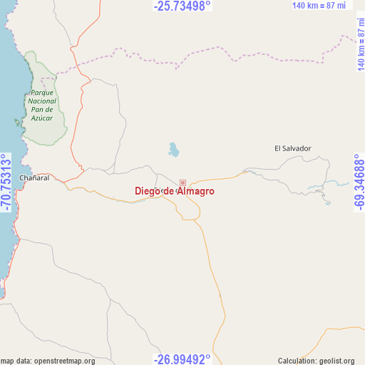
Diego de Almagro GPS coordinates[2]
26° 22' 0.012" South, 70° 3' 0" West
| Map corner | latitude | longitude |
|---|---|---|
| Upper-left | -25.73498°, | -70.75313° |
| Center: | -26.36667°, | -70.05° |
| Lower-right: | -26.99492°, | -69.34688° |
| Map W x H: | 140.1×140.1 km | = 87.1×87.1mi |
| max Lat: | -18.19821° ⇑7.6% North |
| Diego de Almagro: | -26.36667° |
| min Lat: | ⇓92.4% South -54.93355° |
| min Long | Diego de Almagr | max Long |
| -109.42438° | -70.05° | -67.60963° |
| W 95.2%⇐ | ⇒4.8% E |
Elevation
Elevation of Diego de Almagro is 1020 m = 3346 ft, and this is 747 m = 2451 ft above average elevation for this country.
| Max E: |
3544 m = 11627 ft | 4.1% |
| Diego de Almagro | 1020 m 3346 ft | |
| Avg. | 273 m = 896 ft | |
Min E: |
1 m = 3 ft | 95.9% |
See also: Chile elevation on elevation.city.
Geographical zone
Diego de Almagro is located in South temperate zone (between Tropic of Capricorn and the Antarctic Circle). Distance of this Southern Tropic circle is 325.8 km =202.4 mi to North.| Distance of | km | miles | from Diego de Almagro |
|---|---|---|---|
| Equator | 2931.7 | 1821.7 | to North |
| Tropic Capricorn | 325.8 | 202.4 | to North |
| Antarctic Circle | 4469.5 | 2777.2 | to South |
| South Pole | 7075.4 | 4396.4 | to South |


Nearby cities:
10 places around Diego de Almagro: (largest is in red/bold)
• Antofagasta
303.8 km =188.8 mi,  353°
353°
• Chañaral
56.5 km =35.1 mi,  272°
272°
• Copiapó
114.7 km =71.3 mi,  194°
194°
• Coquimbo
418.3 km =259.9 mi,  197°
197°
• La Serena
410.6 km =255.1 mi, 196°
• San Pedro de Atacama
427.2 km =265.4 mi,  25°
25°
• Taltal
115.2 km =71.6 mi,  337°
337°
• Vallenar
239.8 km =149 mi,  184°
184°
• Vallenar
255.4 km =158.7 mi, 195°
• Vicuña
413.1 km =256.7 mi, 189°
Sources, notices
• [Note1] Compared only with cities in Chile existing in our database
• [Src1] Map data: © OpenStreetMap contributors (CC-BY-SA)
• [Src2] Other city data from geonames.org with taken over terms of usage.
• [Src3] Geographical zone / Annual Mean Temperature by Robert A. Rohde @ Wikipedia
