La Serena geodata
La Serena (Coquimbo Region) is a seat of a first-order administrative division; located in Chile in America/Santiago (GMT-4) time zone. With population of 154,521 people, there are 16 cities with bigger population in this country. Compared to other cities in Chile, 89% of cities are located further ↓South; 62.1% of cities are located further ←West and 77.9% of cities have higher elevation than La Serena. Note1


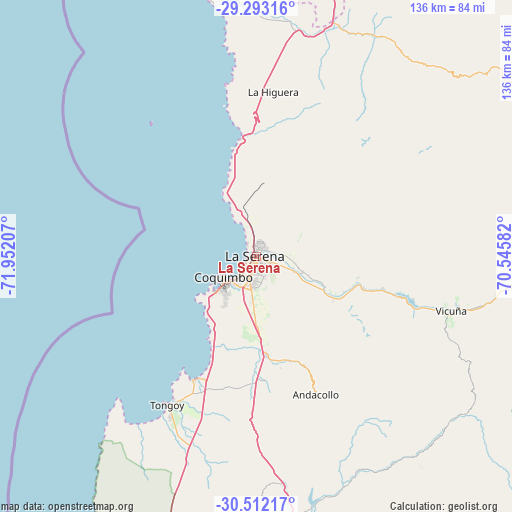
La Serena GPS coordinates[2]
29° 54' 16.308" South, 71° 14' 56.184" West
| Map corner | latitude | longitude |
|---|---|---|
| Upper-left | -29.29316°, | -71.95207° |
| Center: | -29.90453°, | -71.24894° |
| Lower-right: | -30.51217°, | -70.54582° |
| Map W x H: | 135.5×135.5 km | = 84.2×84.2mi |
| max Lat: | -18.19821° ⇑11% North |
| La Serena: | -29.90453° |
| min Lat: | ⇓89% South -54.93355° |
| min Long | La Serena | max Long |
| -109.42438° | -71.24894° | -67.60963° |
| W 62.1%⇐ | ⇒37.9% E |
Elevation
Elevation of La Serena is 30 m = 98 ft, and this is 243 m = 797 ft below average elevation for this country.
| Max E: |
3544 m = 11627 ft | 77.9% |
| Avg. | 273 m = 896 ft | |
| La Serena | 30 m = 98 ft | |
Min E: |
1 m = 3 ft | 22.1% |
See also: La Serena elevation on elevation.city.
Geographical zone
La Serena is located in South temperate zone (between Tropic of Capricorn and the Antarctic Circle). Distance of this Southern Tropic circle is 719.2 km =446.9 mi to North.| Distance of | km | miles | from La Serena |
|---|---|---|---|
| Equator | 3325.1 | 2066.1 | to North |
| Tropic Capricorn | 719.2 | 446.9 | to North |
| Antarctic Circle | 4076.1 | 2532.8 | to South |
| South Pole | 6682 | 4152 | to South |


Nearby cities:
15 places around La Serena: (largest is in red/bold)
• Copiapó
296 km =183.9 mi,  17°
17°
• Coquimbo
10.3 km =6.4 mi,  238°
238°
• Hacienda La Calera
320.1 km =198.9 mi,  179°
179°
• Illapel
192.4 km =119.6 mi, 177°
• La Ligua
283.3 km =176 mi, 179°
• Llaillay
327.6 km =203.6 mi, 175°
• Los Andes
331.5 km =206 mi,  169°
169°
• Monte Patria
92.2 km =57.3 mi,  162°
162°
• Ovalle
77.6 km =48.2 mi, 176°
• Quillota
331.2 km =205.8 mi, 179°
• Salamanca
210.2 km =130.6 mi, 172°
• San Felipe
320.2 km =199 mi, 171°
• Vallenar
155.1 km =96.4 mi, 17°
• Vallenar
182 km =113.1 mi,  31°
31°
• Vicuña
53.7 km =33.4 mi,  105°
105°
Sources, notices
• [Note1] Compared only with cities in Chile existing in our database
• [Src1] Map data: © OpenStreetMap contributors (CC-BY-SA)
• [Src2] Other city data from geonames.org with taken over terms of usage.
• [Src3] Geographical zone / Annual Mean Temperature by Robert A. Rohde @ Wikipedia
