Copiapó geodata
Copiapó (Atacama) is a seat of a first-order administrative division; located in Chile in America/Santiago (GMT-4) time zone. With population of 129,280 people, there are 22 cities with bigger population in this country. Compared to other cities in Chile, 91% of cities are located further ↓South; 91.7% of cities are located further ←West and 81.4% of cities have lower elevation than Copiapó. Note1


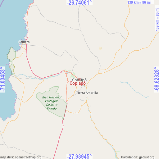
Copiapó GPS coordinates[2]
27° 22' 0.444" South, 70° 19' 53.04" West
| Map corner | latitude | longitude |
|---|---|---|
| Upper-left | -26.74061°, | -71.03453° |
| Center: | -27.36679°, | -70.3314° |
| Lower-right: | -27.98945°, | -69.62828° |
| Map W x H: | 138.9×138.9 km | = 86.3×86.3mi |
| max Lat: | -18.19821° ⇑9% North |
| Copiapó: | -27.36679° |
| min Lat: | ⇓91% South -54.93355° |
| min Long | Copiapó | max Long |
| -109.42438° | -70.3314° | -67.60963° |
| W 91.7%⇐ | ⇒8.3% E |
Elevation
Elevation of Copiapó is 397 m = 1302 ft, and this is 124 m = 407 ft above average elevation for this country.
| Max E: |
3544 m = 11627 ft | 18.6% |
| Copiapó | 397 m 1302 ft | |
| Avg. | 273 m = 896 ft | |
Min E: |
1 m = 3 ft | 81.4% |
See also: Copiapó elevation on elevation.city.
Geographical zone
Copiapó is located in South temperate zone (between Tropic of Capricorn and the Antarctic Circle). Distance of this Southern Tropic circle is 437 km =271.5 mi to North.| Distance of | km | miles | from Copiapó |
|---|---|---|---|
| Equator | 3042.9 | 1890.8 | to North |
| Tropic Capricorn | 437 | 271.5 | to North |
| Antarctic Circle | 4358.3 | 2708.1 | to South |
| South Pole | 6964.2 | 4327.4 | to South |


Nearby cities:
11 places around Copiapó: (largest is in red/bold)
• Antofagasta
413.1 km =256.7 mi,  359°
359°
• Chañaral
117.3 km =72.9 mi,  346°
346°
• Coquimbo
303.9 km =188.8 mi,  198°
198°
• Diego de Almagro
114.7 km =71.3 mi,  14°
14°
• La Serena
296 km =183.9 mi, 197°
• Monte Patria
375 km =233 mi,  189°
189°
• Ovalle
369.4 km =229.5 mi, 193°
• Taltal
218.4 km =135.7 mi, 355°
• Vallenar
128 km =79.5 mi,  176°
176°
• Vallenar
140.9 km =87.6 mi, 197°
• Vicuña
299 km =185.8 mi, 187°
Sources, notices
• [Note1] Compared only with cities in Chile existing in our database
• [Src1] Map data: © OpenStreetMap contributors (CC-BY-SA)
• [Src2] Other city data from geonames.org with taken over terms of usage.
• [Src3] Geographical zone / Annual Mean Temperature by Robert A. Rohde @ Wikipedia
