Nkongsamba geodata
Nkongsamba (Littoral) is a populated place; located in Cameroon in Africa/Douala (GMT+1) time zone. With population of 117,063 people, there are 13 cities with bigger population in this country. Compared to other cities in Cameroon, 50.8% of cities are located further ↓South; 81.1% of cities are located further →East and 71.3% of cities have lower elevation than Nkongsamba. Note1


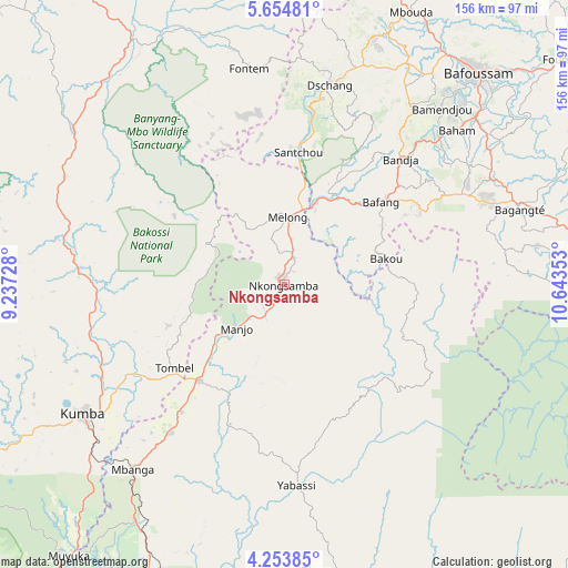
Nkongsamba GPS coordinates[2]
4° 57' 16.92" North, 9° 56' 25.44" East
| Map corner | latitude | longitude |
|---|---|---|
| Upper-left | 5.65481°, | 9.23728° |
| Center: | 4.9547°, | 9.9404° |
| Lower-right: | 4.25385°, | 10.64353° |
| Map W x H: | 155.8×155.8 km | = 96.8×96.8mi |
| max Lat: | 12.57535° ⇑49.2% North |
| Nkongsamba: | 4.9547° |
| min Lat: | ⇓50.8% South 2.35° |
| min Long | Nkongsamba | max Long |
| 8.8724° | 9.9404° | 15.23288° |
| W 18.9%⇐ | ⇒81.1% E |
Elevation
Elevation of Nkongsamba is 844 m = 2769 ft, and this is 170.1 m = 558 ft above average elevation for this country.
| Max E: |
1687 m = 5535 ft | 28.7% |
| Nkongsamba | 844 m 2769 ft | |
| Avg. | 673.9 m = 2211 ft | |
Min E: |
1 m = 3 ft | 71.3% |
See also: Nkongsamba elevation on elevation.city.
Geographical zone
Nkongsamba is located in North Torrid zone (between Equator and Tropic of Cancer). Distance of Equator is 550.9 km =342.3 mi to South.| Distance of | km | miles | from Nkongsamba |
|---|---|---|---|
| North Pole | 9456.2 | 5875.8 | to North |
| Arctic Circle | 6850.3 | 4256.6 | to North |
| Tropic Cancer | 2055 | 1276.9 | to North |
| Equator | 550.9 | 342.3 | to South |


Nearby cities:
15 places around Nkongsamba: (largest is in red/bold)
• Bafang
34.5 km =21.4 mi,  49°
49°
• Bamendjou
64.8 km =40.3 mi,  41°
41°
• Bana
42.8 km =26.6 mi,  60°
60°
• Bazou
59.5 km =37 mi,  78°
78°
• Dschang
55.8 km =34.7 mi,  12°
12°
• Fontem
57.5 km =35.7 mi,  353°
353°
• Kumba
65.1 km =40.5 mi,  237°
237°
• Loum
34.8 km =21.6 mi,  220°
220°
• Manjo
18.1 km =11.2 mi,  226°
226°
• Mbanga
65.2 km =40.5 mi, 219°
• Melong
18.7 km =11.6 mi, 7°
• Ndom
65.8 km =40.9 mi, 219°
• Ngou
56.2 km =34.9 mi, 61°
• Penja
45.4 km =28.2 mi, 219°
• Yabassi
55.4 km =34.4 mi,  176°
176°
Sources, notices
• [Note1] Compared only with cities in Cameroon existing in our database
• [Src1] Map data: © OpenStreetMap contributors (CC-BY-SA)
• [Src2] Other city data from geonames.org with taken over terms of usage.
• [Src3] Geographical zone / Annual Mean Temperature by Robert A. Rohde @ Wikipedia
