Melong geodata
Melong (Littoral) is a populated place; located in Cameroon in Africa/Douala (GMT+1) time zone. With population of 37,086 people, there are 44 cities with bigger population in this country. Compared to other cities in Cameroon, 53.3% of cities are located further ↓South; 80.3% of cities are located further →East and 67.2% of cities have lower elevation than Melong. Note1


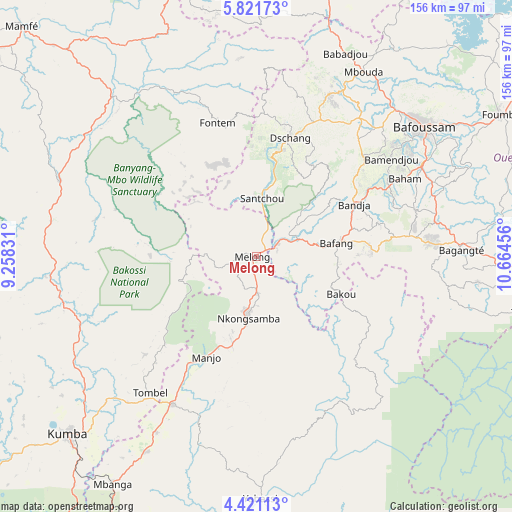
Melong GPS coordinates[2]
5° 7' 18.516" North, 9° 57' 41.148" East
| Map corner | latitude | longitude |
|---|---|---|
| Upper-left | 5.82173°, | 9.25831° |
| Center: | 5.12181°, | 9.96143° |
| Lower-right: | 4.42113°, | 10.66456° |
| Map W x H: | 155.7×155.7 km | = 96.7×96.7mi |
| max Lat: | 12.57535° ⇑46.7% North |
| Melong: | 5.12181° |
| min Lat: | ⇓53.3% South 2.35° |
| min Long | Melong | max Long |
| 8.8724° | 9.96143° | 15.23288° |
| W 19.7%⇐ | ⇒80.3% E |
Elevation
Elevation of Melong is 792 m = 2598 ft, and this is 118.1 m = 387 ft above average elevation for this country.
| Max E: |
1687 m = 5535 ft | 32.8% |
| Melong | 792 m 2598 ft | |
| Avg. | 673.9 m = 2211 ft | |
Min E: |
1 m = 3 ft | 67.2% |
See also: Cameroon elevation on elevation.city.
Geographical zone
Melong is located in North Torrid zone (between Equator and Tropic of Cancer). Distance of Equator is 569.5 km =353.9 mi to South.| Distance of | km | miles | from Melong |
|---|---|---|---|
| North Pole | 9437.6 | 5864.3 | to North |
| Arctic Circle | 6831.7 | 4245 | to North |
| Tropic Cancer | 2036.4 | 1265.4 | to North |
| Equator | 569.5 | 353.9 | to South |


Nearby cities:
15 places around Melong: (largest is in red/bold)
• Bafang
24.2 km =15 mi,  80°
80°
• Bafoussam
64.2 km =39.9 mi,  51°
51°
• Bamendjou
50.5 km =31.4 mi, 53°
• Bana
34.9 km =21.7 mi,  85°
85°
• Bandjoun
57.4 km =35.7 mi,  60°
60°
• Bangangté
62.5 km =38.8 mi, 88°
• Bansoa
53.3 km =33.1 mi, 47°
• Bazou
56.5 km =35.1 mi,  96°
96°
• Dschang
37.2 km =23.1 mi,  15°
15°
• Fontem
39.5 km =24.5 mi,  347°
347°
• Loum
51.4 km =31.9 mi,  209°
209°
• Manjo
34.7 km =21.6 mi, 206°
• Ngou
47.7 km =29.6 mi, 79°
• Nkongsamba
18.7 km =11.6 mi,  187°
187°
• Penja
62.1 km =38.6 mi, 210°
Sources, notices
• [Note1] Compared only with cities in Cameroon existing in our database
• [Src1] Map data: © OpenStreetMap contributors (CC-BY-SA)
• [Src2] Other city data from geonames.org with taken over terms of usage.
• [Src3] Geographical zone / Annual Mean Temperature by Robert A. Rohde @ Wikipedia
