Ngou geodata
Ngou (West) is a populated place; located in Cameroon in Africa/Douala (GMT+1) time zone. With population of 7,560 people, there are 82 cities with bigger population in this country. Compared to other cities in Cameroon, 56.6% of cities are located further ↓South; 63.9% of cities are located further →East and 94.3% of cities have lower elevation than Ngou. Note1


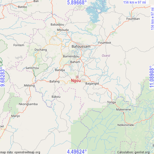
Ngou GPS coordinates[2]
5° 11' 48.66" North, 10° 23' 9.42" East
| Map corner | latitude | longitude |
|---|---|---|
| Upper-left | 5.89668°, | 9.68283° |
| Center: | 5.19685°, | 10.38595° |
| Lower-right: | 4.49624°, | 11.08908° |
| Map W x H: | 155.7×155.7 km | = 96.7×96.7mi |
| max Lat: | 12.57535° ⇑43.4% North |
| Ngou: | 5.19685° |
| min Lat: | ⇓56.6% South 2.35° |
| min Long | Ngou | max Long |
| 8.8724° | 10.38595° | 15.23288° |
| W 36.1%⇐ | ⇒63.9% E |
Elevation
Elevation of Ngou is 1441 m = 4728 ft, and this is 767.1 m = 2517 ft above average elevation for this country.
| Max E: |
1687 m = 5535 ft | 5.7% |
| Ngou | 1441 m 4728 ft | |
| Avg. | 673.9 m = 2211 ft | |
Min E: |
1 m = 3 ft | 94.3% |
See also: Cameroon elevation on elevation.city.
Geographical zone
Ngou is located in North Torrid zone (between Equator and Tropic of Cancer). Distance of Equator is 577.8 km =359 mi to South.| Distance of | km | miles | from Ngou |
|---|---|---|---|
| North Pole | 9429.2 | 5859 | to North |
| Arctic Circle | 6823.3 | 4239.8 | to North |
| Tropic Cancer | 2028.1 | 1260.2 | to North |
| Equator | 577.8 | 359 | to South |


Nearby cities:
15 places around Ngou: (largest is in red/bold)
• Bafang
23.5 km =14.6 mi,  259°
259°
• Bafoussam
31.4 km =19.5 mi,  6°
6°
• Bamendjou
22.3 km =13.9 mi,  343°
343°
• Bana
13.5 km =8.4 mi,  245°
245°
• Bandjoun
20.1 km =12.5 mi, 8°
• Bangangté
16.6 km =10.3 mi,  111°
111°
• Bansoa
29.1 km =18.1 mi, 344°
• Bazou
17.7 km =11 mi,  149°
149°
• Dschang
45.9 km =28.5 mi,  306°
306°
• Fontem
63.5 km =39.5 mi,  298°
298°
• Foumbot
44.1 km =27.4 mi,  38°
38°
• Mbouda
49.9 km =31 mi, 343°
• Melong
47.7 km =29.6 mi, 259°
• Nkongsamba
56.2 km =34.9 mi,  241°
241°
• Tonga
43.2 km =26.8 mi,  126°
126°
Sources, notices
• [Note1] Compared only with cities in Cameroon existing in our database
• [Src1] Map data: © OpenStreetMap contributors (CC-BY-SA)
• [Src2] Other city data from geonames.org with taken over terms of usage.
• [Src3] Geographical zone / Annual Mean Temperature by Robert A. Rohde @ Wikipedia
