Bangangté geodata
Bangangté (West) is a populated place; located in Cameroon in Africa/Douala (GMT+1) time zone. With population of 65,385 people, there are 28 cities with bigger population in this country. Compared to other cities in Cameroon, 54.1% of cities are located further ↓South; 60.7% of cities are located further →East and 88.5% of cities have lower elevation than Bangangté. Note1


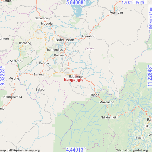
Bangangté GPS coordinates[2]
5° 8' 26.844" North, 10° 31' 31.26" East
| Map corner | latitude | longitude |
|---|---|---|
| Upper-left | 5.84068°, | 9.82223° |
| Center: | 5.14079°, | 10.52535° |
| Lower-right: | 4.44013°, | 11.22848° |
| Map W x H: | 155.7×155.7 km | = 96.7×96.7mi |
| max Lat: | 12.57535° ⇑45.9% North |
| Bangangté: | 5.14079° |
| min Lat: | ⇓54.1% South 2.35° |
| min Long | Bangangté | max Long |
| 8.8724° | 10.52535° | 15.23288° |
| W 39.3%⇐ | ⇒60.7% E |
Elevation
Elevation of Bangangté is 1337 m = 4386 ft, and this is 663.1 m = 2176 ft above average elevation for this country.
| Max E: |
1687 m = 5535 ft | 11.5% |
| Bangangté | 1337 m 4386 ft | |
| Avg. | 673.9 m = 2211 ft | |
Min E: |
1 m = 3 ft | 88.5% |
See also: Bangangté elevation on elevation.city.
Geographical zone
Bangangté is located in North Torrid zone (between Equator and Tropic of Cancer). Distance of Equator is 571.6 km =355.2 mi to South.| Distance of | km | miles | from Bangangté |
|---|---|---|---|
| North Pole | 9435.5 | 5862.9 | to North |
| Arctic Circle | 6829.6 | 4243.7 | to North |
| Tropic Cancer | 2034.3 | 1264.1 | to North |
| Equator | 571.6 | 355.2 | to South |


Nearby cities:
15 places around Bangangté: (largest is in red/bold)
• Bafang
38.6 km =24 mi,  272°
272°
• Bafoussam
39.3 km =24.4 mi,  342°
342°
• Bamendjou
35.1 km =21.8 mi,  322°
322°
• Bana
27.7 km =17.2 mi, 271°
• Bandjoun
28.9 km =18 mi,  334°
334°
• Bansoa
41.5 km =25.8 mi, 325°
• Bazou
11 km =6.8 mi,  215°
215°
• Dschang
62.2 km =38.6 mi,  302°
302°
• Foumbot
42.5 km =26.4 mi,  16°
16°
• Mbouda
61.7 km =38.3 mi, 330°
• Melong
62.5 km =38.8 mi, 268°
• Ndikiniméki
53.8 km =33.4 mi,  140°
140°
• Ngou
16.6 km =10.3 mi,  291°
291°
• Nkongsamba
68 km =42.3 mi,  252°
252°
• Tonga
27.4 km =17 mi, 135°
Sources, notices
• [Note1] Compared only with cities in Cameroon existing in our database
• [Src1] Map data: © OpenStreetMap contributors (CC-BY-SA)
• [Src2] Other city data from geonames.org with taken over terms of usage.
• [Src3] Geographical zone / Annual Mean Temperature by Robert A. Rohde @ Wikipedia
