Foumbot geodata
Foumbot (West) is a populated place; located in Cameroon in Africa/Douala (GMT+1) time zone. With population of 84,065 people, there are 19 cities with bigger population in this country. Compared to other cities in Cameroon, 63.1% of cities are located further ↓South; 57.4% of cities are located further →East and 76.2% of cities have lower elevation than Foumbot. Note1


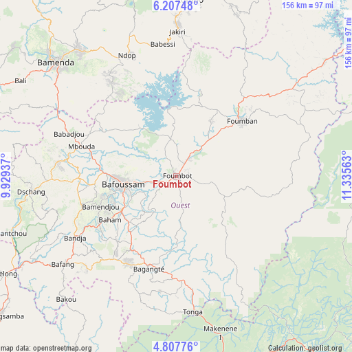
Foumbot GPS coordinates[2]
5° 30' 28.908" North, 10° 37' 57" East
| Map corner | latitude | longitude |
|---|---|---|
| Upper-left | 6.20748°, | 9.92937° |
| Center: | 5.50803°, | 10.6325° |
| Lower-right: | 4.80776°, | 11.33563° |
| Map W x H: | 155.6×155.6 km | = 96.7×96.7mi |
| max Lat: | 12.57535° ⇑36.9% North |
| Foumbot: | 5.50803° |
| min Lat: | ⇓63.1% South 2.35° |
| min Long | Foumbot | max Long |
| 8.8724° | 10.6325° | 15.23288° |
| W 42.6%⇐ | ⇒57.4% E |
Elevation
Elevation of Foumbot is 1054 m = 3458 ft, and this is 380.1 m = 1247 ft above average elevation for this country.
| Max E: |
1687 m = 5535 ft | 23.8% |
| Foumbot | 1054 m 3458 ft | |
| Avg. | 673.9 m = 2211 ft | |
Min E: |
1 m = 3 ft | 76.2% |
See also: Foumbot elevation on elevation.city.
Geographical zone
Foumbot is located in North Torrid zone (between Equator and Tropic of Cancer). Distance of Equator is 612.4 km =380.5 mi to South.| Distance of | km | miles | from Foumbot |
|---|---|---|---|
| North Pole | 9394.6 | 5837.5 | to North |
| Arctic Circle | 6788.7 | 4218.3 | to North |
| Tropic Cancer | 1993.5 | 1238.7 | to North |
| Equator | 612.4 | 380.5 | to South |


Nearby cities:
15 places around Foumbot: (largest is in red/bold)
• Bafang
63.8 km =39.6 mi,  232°
232°
• Bafoussam
24 km =14.9 mi,  261°
261°
• Bamenda
73.6 km =45.7 mi,  313°
313°
• Bamendjou
36 km =22.4 mi,  248°
248°
• Bana
56.4 km =35 mi,  224°
224°
• Bandjoun
28.4 km =17.6 mi,  238°
238°
• Bangangté
42.5 km =26.4 mi,  196°
196°
• Bansoa
35.9 km =22.3 mi, 259°
• Bazou
53.1 km =33 mi, 200°
• Dschang
64.5 km =40.1 mi, 263°
• Foumban
38.2 km =23.7 mi,  50°
50°
• Jakiri
65.8 km =40.9 mi,  1°
1°
• Mbouda
43.9 km =27.3 mi,  287°
287°
• Ngou
44.1 km =27.4 mi, 218°
• Tonga
60.7 km =37.7 mi,  172°
172°
Sources, notices
• [Note1] Compared only with cities in Cameroon existing in our database
• [Src1] Map data: © OpenStreetMap contributors (CC-BY-SA)
• [Src2] Other city data from geonames.org with taken over terms of usage.
• [Src3] Geographical zone / Annual Mean Temperature by Robert A. Rohde @ Wikipedia
