Bandjoun geodata
Bandjoun (West) is a populated place; located in Cameroon in Africa/Douala (GMT+1) time zone. With population of 6,872 people, there are 87 cities with bigger population in this country. Compared to other cities in Cameroon, 58.2% of cities are located further ↓South; 63.1% of cities are located further →East and 96.7% of cities have lower elevation than Bandjoun. Note1


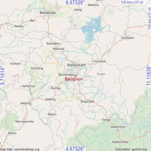
Bandjoun GPS coordinates[2]
5° 22' 32.448" North, 10° 24' 47.736" East
| Map corner | latitude | longitude |
|---|---|---|
| Upper-left | 6.07529°, | 9.71014° |
| Center: | 5.37568°, | 10.41326° |
| Lower-right: | 4.67526°, | 11.11639° |
| Map W x H: | 155.7×155.7 km | = 96.7×96.7mi |
| max Lat: | 12.57535° ⇑41.8% North |
| Bandjoun: | 5.37568° |
| min Lat: | ⇓58.2% South 2.35° |
| min Long | Bandjoun | max Long |
| 8.8724° | 10.41326° | 15.23288° |
| W 36.9%⇐ | ⇒63.1% E |
Elevation
Elevation of Bandjoun is 1529 m = 5016 ft, and this is 855.1 m = 2805 ft above average elevation for this country.
| Max E: |
1687 m = 5535 ft | 3.3% |
| Bandjoun | 1529 m 5016 ft | |
| Avg. | 673.9 m = 2211 ft | |
Min E: |
1 m = 3 ft | 96.7% |
See also: Cameroon elevation on elevation.city.
Geographical zone
Bandjoun is located in North Torrid zone (between Equator and Tropic of Cancer). Distance of Equator is 597.7 km =371.4 mi to South.| Distance of | km | miles | from Bandjoun |
|---|---|---|---|
| North Pole | 9409.3 | 5846.7 | to North |
| Arctic Circle | 6803.5 | 4227.5 | to North |
| Tropic Cancer | 2008.2 | 1247.8 | to North |
| Equator | 597.7 | 371.4 | to South |


Nearby cities:
15 places around Bandjoun: (largest is in red/bold)
• Bafang
35.7 km =22.2 mi,  227°
227°
• Bafoussam
11.4 km =7.1 mi,  2°
2°
• Bamendjou
9.3 km =5.8 mi,  279°
279°
• Bana
29.7 km =18.5 mi,  210°
210°
• Bangangté
28.9 km =18 mi,  154°
154°
• Bansoa
13.7 km =8.5 mi,  306°
306°
• Bazou
35.6 km =22.1 mi,  170°
170°
• Dschang
40.6 km =25.2 mi, 280°
• Fontem
59.7 km =37.1 mi, 279°
• Foumban
66.4 km =41.3 mi,  54°
54°
• Foumbot
28.4 km =17.6 mi,  58°
58°
• Mbouda
32.9 km =20.4 mi,  327°
327°
• Melong
57.4 km =35.7 mi,  240°
240°
• Ngou
20.1 km =12.5 mi,  188°
188°
• Tonga
55.5 km =34.5 mi, 145°
Sources, notices
• [Note1] Compared only with cities in Cameroon existing in our database
• [Src1] Map data: © OpenStreetMap contributors (CC-BY-SA)
• [Src2] Other city data from geonames.org with taken over terms of usage.
• [Src3] Geographical zone / Annual Mean Temperature by Robert A. Rohde @ Wikipedia
