Mouanko geodata
Mouanko (Littoral) is a populated place; located in Cameroon in Africa/Douala (GMT+1) time zone. With population of 1,604 people, there are 119 cities with bigger population in this country. Compared to other cities in Cameroon, 90.2% of cities are located further ↑North; 85.2% of cities are located further →East and 97.5% of cities have higher elevation than Mouanko. Note1


Mouanko GPS coordinates[2]
3° 38' 22.992" North, 9° 46' 36.984" East
| Map corner | latitude | longitude |
|---|---|---|
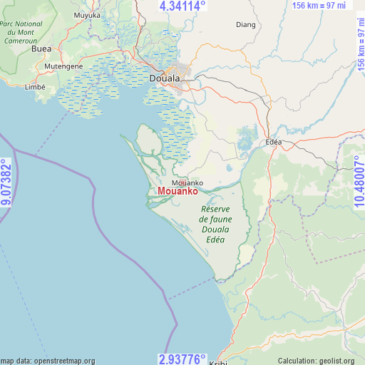
| Upper-left | 4.34114°, | 9.07382° |
| Center: | 3.63972°, | 9.77694° |
| Lower-right: | 2.93776°, | 10.48007° |
| Map W x H: | 156×156 km | = 96.9×96.9mi |
| max Lat: | 12.57535° ⇑90.2% North |
| Mouanko: | 3.63972° |
| min Lat: | ⇓9.8% South 2.35° |
| min Long | Mouanko | max Long |
| 8.8724° | 9.77694° | 15.23288° |
| W 14.8%⇐ | ⇒85.2% E |
Elevation
Elevation of Mouanko is 13 m = 43 ft, and this is 660.9 m = 2168 ft below average elevation for this country.
| Max E: |
1687 m = 5535 ft | 97.5% |
| Avg. | 673.9 m = 2211 ft | |
| Mouanko | 13 m = 43 ft | |
Min E: |
1 m = 3 ft | 2.5% |
See also: Cameroon elevation on elevation.city.
Geographical zone
Mouanko is located in North Torrid zone (between Equator and Tropic of Cancer). Distance of Equator is 404.7 km =251.5 mi to South.| Distance of | km | miles | from Mouanko |
|---|---|---|---|
| North Pole | 9602.4 | 5966.7 | to North |
| Arctic Circle | 6996.5 | 4347.4 | to North |
| Tropic Cancer | 2201.2 | 1367.8 | to North |
| Equator | 404.7 | 251.5 | to South |


Nearby cities:
15 places around Mouanko: (largest is in red/bold)
• Bonabéri
49.1 km =30.5 mi,  347°
347°
• Buea
82.3 km =51.1 mi,  313°
313°
• Diang
72.9 km =45.3 mi,  21°
21°
• Dibombari
61.4 km =38.2 mi, 347°
• Dizangué
26.9 km =16.7 mi,  58°
58°
• Douala
46.1 km =28.6 mi, 349°
• Edéa
43.4 km =27 mi,  65°
65°
• Kribi
79.4 km =49.3 mi,  169°
169°
• Limbe
76.4 km =47.5 mi,  303°
303°
• Mbanga
98.6 km =61.3 mi, 346°
• Mutengene
71.8 km =44.6 mi, 314°
• Muyuka
82.9 km =51.5 mi,  330°
330°
• Ndom
98.3 km =61.1 mi, 346°
• Tiko
66.9 km =41.6 mi,  316°
316°
• Yabassi
93.3 km =58 mi,  13°
13°
Sources, notices
• [Note1] Compared only with cities in Cameroon existing in our database
• [Src1] Map data: © OpenStreetMap contributors (CC-BY-SA)
• [Src2] Other city data from geonames.org with taken over terms of usage.
• [Src3] Geographical zone / Annual Mean Temperature by Robert A. Rohde @ Wikipedia
