Diang geodata
Diang (Littoral) is a populated place; located in Cameroon in Africa/Douala (GMT+1) time zone. With population of 2,062 people, there are 115 cities with bigger population in this country. Compared to other cities in Cameroon, 71.3% of cities are located further ↑North; 76.2% of cities are located further →East and 92.6% of cities have higher elevation than Diang. Note1


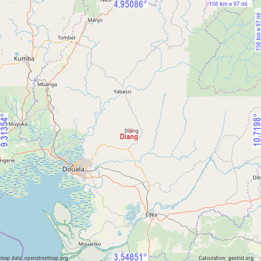
Diang GPS coordinates[2]
4° 15' 0" North, 10° 1' 0.012" East
| Map corner | latitude | longitude |
|---|---|---|
| Upper-left | 4.95086°, | 9.31354° |
| Center: | 4.25°, | 10.01667° |
| Lower-right: | 3.54851°, | 10.7198° |
| Map W x H: | 155.9×155.9 km | = 96.9×96.9mi |
| max Lat: | 12.57535° ⇑71.3% North |
| Diang: | 4.25° |
| min Lat: | ⇓28.7% South 2.35° |
| min Long | Diang | max Long |
| 8.8724° | 10.01667° | 15.23288° |
| W 23.8%⇐ | ⇒76.2% E |
Elevation
Elevation of Diang is 56 m = 184 ft, and this is 617.9 m = 2027 ft below average elevation for this country.
| Max E: |
1687 m = 5535 ft | 92.6% |
| Avg. | 673.9 m = 2211 ft | |
| Diang | 56 m = 184 ft | |
Min E: |
1 m = 3 ft | 7.4% |
See also: Cameroon elevation on elevation.city.
Geographical zone
Diang is located in North Torrid zone (between Equator and Tropic of Cancer). Distance of Equator is 472.6 km =293.7 mi to South.| Distance of | km | miles | from Diang |
|---|---|---|---|
| North Pole | 9534.5 | 5924.5 | to North |
| Arctic Circle | 6928.6 | 4305.2 | to North |
| Tropic Cancer | 2133.4 | 1325.6 | to North |
| Equator | 472.6 | 293.7 | to South |


Nearby cities:
15 places around Diang: (largest is in red/bold)
• Bonabéri
42.1 km =26.2 mi,  241°
241°
• Dibombari
40.8 km =25.4 mi,  258°
258°
• Dizangué
53.9 km =33.5 mi,  183°
183°
• Douala
41.3 km =25.7 mi, 237°
• Edéa
51.7 km =32.1 mi,  165°
165°
• Loum
60.7 km =37.7 mi,  329°
329°
• Manjo
69.4 km =43.1 mi,  341°
341°
• Mbanga
57.2 km =35.5 mi,  299°
299°
• Mouanko
72.9 km =45.3 mi,  201°
201°
• Muyuka
67.4 km =41.9 mi,  273°
273°
• Ndom
57.4 km =35.7 mi, 298°
• Ngambé
66.4 km =41.3 mi,  91°
91°
• Penja
57.1 km =35.5 mi,  319°
319°
• Tiko
75.4 km =46.9 mi, 255°
• Yabassi
23.6 km =14.7 mi,  346°
346°
Sources, notices
• [Note1] Compared only with cities in Cameroon existing in our database
• [Src1] Map data: © OpenStreetMap contributors (CC-BY-SA)
• [Src2] Other city data from geonames.org with taken over terms of usage.
• [Src3] Geographical zone / Annual Mean Temperature by Robert A. Rohde @ Wikipedia
