Dizangué geodata
Dizangué (Littoral) is a populated place; located in Cameroon in Africa/Douala (GMT+1) time zone. With population of 19,243 people, there are 59 cities with bigger population in this country. Compared to other cities in Cameroon, 88.5% of cities are located further ↑North; 78.7% of cities are located further →East and 91% of cities have higher elevation than Dizangué. Note1


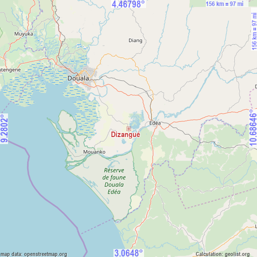
Dizangué GPS coordinates[2]
3° 46' 0.012" North, 9° 58' 59.988" East
| Map corner | latitude | longitude |
|---|---|---|
| Upper-left | 4.46798°, | 9.2802° |
| Center: | 3.76667°, | 9.98333° |
| Lower-right: | 3.0648°, | 10.68646° |
| Map W x H: | 156×156 km | = 96.9×96.9mi |
| max Lat: | 12.57535° ⇑88.5% North |
| Dizangué: | 3.76667° |
| min Lat: | ⇓11.5% South 2.35° |
| min Long | Dizangué | max Long |
| 8.8724° | 9.98333° | 15.23288° |
| W 21.3%⇐ | ⇒78.7% E |
Elevation
Elevation of Dizangué is 61 m = 200 ft, and this is 612.9 m = 2011 ft below average elevation for this country.
| Max E: |
1687 m = 5535 ft | 91% |
| Avg. | 673.9 m = 2211 ft | |
| Dizangué | 61 m = 200 ft | |
Min E: |
1 m = 3 ft | 9% |
See also: Cameroon elevation on elevation.city.
Geographical zone
Dizangué is located in North Torrid zone (between Equator and Tropic of Cancer). Distance of Equator is 418.8 km =260.2 mi to South.| Distance of | km | miles | from Dizangué |
|---|---|---|---|
| North Pole | 9588.2 | 5957.8 | to North |
| Arctic Circle | 6982.4 | 4338.7 | to North |
| Tropic Cancer | 2187.1 | 1359 | to North |
| Equator | 418.8 | 260.2 | to South |


Nearby cities:
15 places around Dizangué: (largest is in red/bold)
• Bonabéri
47.6 km =29.6 mi,  315°
315°
• Buea
92.8 km =57.7 mi,  297°
297°
• Diang
53.9 km =33.5 mi,  3°
3°
• Dibombari
58.4 km =36.3 mi, 321°
• Douala
44 km =27.3 mi, 315°
• Edéa
17 km =10.6 mi,  77°
77°
• Eséka
87.9 km =54.6 mi,  98°
98°
• Kribi
92.6 km =57.5 mi,  185°
185°
• Limbe
90.8 km =56.4 mi,  288°
288°
• Mouanko
26.9 km =16.7 mi,  238°
238°
• Mutengene
82.5 km =51.3 mi, 295°
• Muyuka
86.2 km =53.6 mi,  312°
312°
• Ngambé
87.2 km =54.2 mi,  53°
53°
• Tiko
77.2 km =48 mi, 296°
• Yabassi
76.8 km =47.7 mi,  358°
358°
Sources, notices
• [Note1] Compared only with cities in Cameroon existing in our database
• [Src1] Map data: © OpenStreetMap contributors (CC-BY-SA)
• [Src2] Other city data from geonames.org with taken over terms of usage.
• [Src3] Geographical zone / Annual Mean Temperature by Robert A. Rohde @ Wikipedia
