Ébolowa geodata
Ébolowa (South) is a seat of a first-order administrative division; located in Cameroon in Africa/Douala (GMT+1) time zone. With population of 87,875 people, there are 17 cities with bigger population in this country. Compared to other cities in Cameroon, 97.5% of cities are located further ↑North; 50.8% of cities are located further →East and 54.1% of cities have higher elevation than Ébolowa. Note1


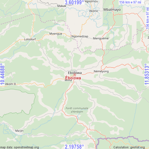
Ébolowa GPS coordinates[2]
2° 54' 0" North, 11° 9' 0" East
| Map corner | latitude | longitude |
|---|---|---|
| Upper-left | 3.60199°, | 10.44688° |
| Center: | 2.9°, | 11.15° |
| Lower-right: | 2.19758°, | 11.85313° |
| Map W x H: | 156.2×156.2 km | = 97.1×97.1mi |
| max Lat: | 12.57535° ⇑97.5% North |
| Ébolowa: | 2.9° |
| min Lat: | ⇓2.5% South 2.35° |
| min Long | Ébolowa | max Long |
| 8.8724° | 11.15° | 15.23288° |
| W 49.2%⇐ | ⇒50.8% E |
Elevation
Elevation of Ébolowa is 583 m = 1913 ft, and this is 90.9 m = 298 ft below average elevation for this country.
| Max E: |
1687 m = 5535 ft | 54.1% |
| Avg. | 673.9 m = 2211 ft | |
| Ébolowa | 583 m = 1913 ft | |
Min E: |
1 m = 3 ft | 45.9% |
See also: Ébolowa elevation on elevation.city.
Geographical zone
Ébolowa is located in North Torrid zone (between Equator and Tropic of Cancer). Distance of Equator is 322.4 km =200.3 mi to South.| Distance of | km | miles | from Ébolowa |
|---|---|---|---|
| North Pole | 9684.6 | 6017.7 | to North |
| Arctic Circle | 7078.7 | 4398.5 | to North |
| Tropic Cancer | 2283.5 | 1418.9 | to North |
| Equator | 322.4 | 200.3 | to South |


Nearby cities:
15 places around Ébolowa: (largest is in red/bold)
• Akom II
66.1 km =41.1 mi,  258°
258°
• Akono
69.7 km =43.3 mi,  16°
16°
• Ambam
59.3 km =36.8 mi,  165°
165°
• Eséka
93.6 km =58.2 mi,  332°
332°
• Lolodorf
59.3 km =36.8 mi,  308°
308°
• Maan
85.1 km =52.9 mi,  224°
224°
• Mbalmayo
78.8 km =49 mi,  29°
29°
• Mbankomo
101.6 km =63.1 mi,  14°
14°
• Mvangué
41.4 km =25.7 mi,  79°
79°
• Ngomedzap
39.3 km =24.4 mi, 8°
• Okoa
130.4 km =81 mi, 22°
• Okola
126.8 km =78.8 mi, 11°
• Sangmélima
92.6 km =57.5 mi,  87°
87°
• Yaoundé
114.9 km =71.4 mi, 20°
• Évodoula
131.7 km =81.8 mi,  2°
2°
Sources, notices
• [Note1] Compared only with cities in Cameroon existing in our database
• [Src1] Map data: © OpenStreetMap contributors (CC-BY-SA)
• [Src2] Other city data from geonames.org with taken over terms of usage.
• [Src3] Geographical zone / Annual Mean Temperature by Robert A. Rohde @ Wikipedia
